This semester our 5th Year Architecture comprehensive studio project is for a 12,000-seat velodrome (an indoor competitive cycling track) in Cambridge, Massachusetts, on an open site along the Charles River that is currently used for athletic fields. During the first week we were challenged to choose a past theme from Cabinet Magazine, from which to construct a conceptual frame and thesis relating to the discipline of architecture, the City of Boston, and competitive cycling. I was quickly drawn to the Spring 2001 issue theme, “Mapping Conversations” and became even more intrigued upon reading its features.
In Frances Richard’s article Utterance is Place Enough she explores what maps are and how we create and use them to define our places and communication spatial comprehension (directions perhaps). Mapping is a method for articulating the existing of things in our physical environment – by showing them on a map, it establishes their importance or permanence. In regard to conversation, it is abstracted as an unscripted verbal exchange between two or more participants. Since it is unpredictable and not pre-established, conversation is not permanent in the way things and places are in space, rather it is a temporary discourse. Continuing, how is mapping conversation different from writing? Richard argues maps and writing are artifacts experienced once removed, whereas conversation is experienced up front and necessarily interactive.
Mark Lombardi created “narrative structure” drawings using lines and notations to index or “map” discourse between political and financial leaders to expose fraud and abuse of powers. Warren Sack looks at mapping very large-scale conversations through the contemporary medium of the internet. Historically mass conversation took place in large-scale public spaces, but the internet can reach a much greater audience with anonymity, but also allows for more direct feedback or discourse. Sack looks at social media networks, “mass media,” and other digital dialogue, using several different kinds of graphs and charts to establish themes and comprehension of these large-scale conversations.
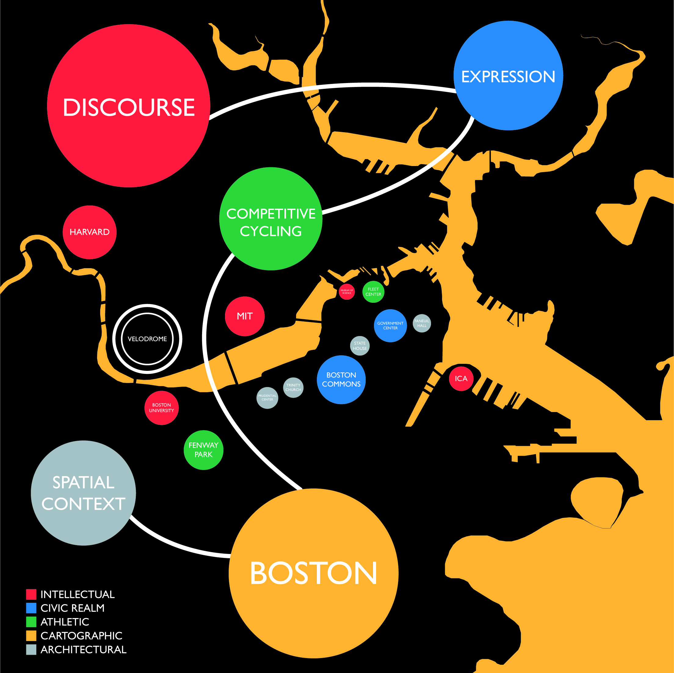
From these articles, which I admittedly summarized pretty poorly, I took the mapping aspect and began to consider the different kinds of actual, spatial, and conceptual conversations active in Boston that would or could in some manner contribute to or have an effect on the proposed velodrome. Utilizing the colors of Boston’s subway lines, I devised five different categories or layers of “conversation” to be represented. Particular institutions and places are mapped geographically, which are significant participants in their given color-coded conversation. Then I was able to create a framework for the design of the velodrome and how it will engage and contribute to these conversations currently taking place in the city. I often use word diagrams, arrows, and notations to organize and plan out objective and key components of a design or piece of writing, so this was actually a very constructive exercise for me.
1. Influence of significant educational institutions nearby (Red)
2. Consideration for public space (Blue),
3. Impact of other athletic facilities and traditions in Boston (Green)
4. Transport and physical connectivity to different parts of Boston (Orange)
5. Contextual relationship with existing urban pattern and significant architecture (Silver)