Tag: redevelopment

First Street Parkade 50 Years Down

First Street Parkade construction

First Street Parkade

First Street Parkade

First Street Parkade demo

After fifty years of gracing Cedar Rapids’ downtown riverfront, the First Street Parkade and its iconic spiral ramp have reached their end. Built in 1961, the four-story ramp would provide over 400 parking spaces for patrons of the downtown retail scene, as competition from newer suburban outlets was increasing. In recent years the structure’s use would be dominated by daytime office workers.

When constructed the new parkade had a commanding presence downtown – few structures at that time occupied the entire length of a city block. Three elevations (north, east and south) that did not face the river were characterized by long, level horizontal planes, articulated by minimalist vertical supports. Along First Street, sections of the top deck wall were clad in dark tinted glass, perhaps an attempt to break up the non-varying facade to relate to the scale of existing storefront buildings across the street.

The river facade was much more dynamic. Angled ramps that let motorists ascend to the top deck were left undisguised, sloping in the same direction as river’s flow. The center was marked by an incredible spiral ramp, partially extending out over the water, cutting through the elegant balustrade lining the existing river wall. Exposed by the demolition process, the concrete spiral was self-supporting, cantilevering from the massive circular core.

While the spiral certainly added a point of visual interest along the river, more impressive was the experience driving down it, framing a sequence of views toward iconic public buildings like City Hall, the county courthouse, and the municipal greenspace of Mays Island. The orientation of views from the ramp reinforced long-standing symbols of civic pride. Likewise the parkade was a new point of pride for the city – a sign of modern progress and optimism for the future, heralded as a means to save downtown from its looming demise.

After the 2008 flood, replacing the First Street Parkade became more imminent, having already reached the end of its useful life. Once demolition is complete the site will be turned into surface parking for the time being – an acceptable temporary use. The important riverfront site is now ripe for redevelopment and, once again, has the opportunity to be a catalyst for downtown progress and civic pride for fifty more years to come. Only this time, it will be for people, not cars.

University partnership key to Campustown success

LANE4 Property Group is a development company hired by the City of Ames to devise an implement a plan to redevelop Campustown into a more vibrant and attractive commercial district serving the Iowa State University community. Campustown has great potential as illustrated during a public meeting in the MU on Sept. 29, where LANE4 presented a preliminary concept of what the neighborhood could become.

Major components proposed include bringing back a small grocery or drugstore, a small hotel – which would take the place of the existing MU Hotel, office space (much of which will be leased by ISU) to increase daytime activity, a greater variety of dinning options, and a unique movie theater that could double as lecture hall space for the university. While specifics are yet to be determined, the redevelopment project would likely replace a majority of the existing buildings, which I have some reservations about. However, if certain historic and architecturally significant buildings can be restored and integrated, it is certainly worth some demolition of less critical buildings. Campustown redevelopment will occur in phases over time, but some construction could begin within a year according to LANE4.

A letter in the October 7th Iowa State Daily expressed concern over university offices and lecture facilities locating in Campustown, so I wrote a response explaining why it is critical for the university to be involved. Certain new uses and business likely could not be sustained without the partnerships that are being proposed. You can read my letter in the Iowa State Daily here.

> Iowa State Daily: Opinion – University partnership key to Campustown success
> LANE4 Property Group

City Developments

It’s been a busy news week in Cedar Rapids regarded the city’s future and upcoming redevelopment.

New City Manager
On Tuesday night the City Council unanimously voted in favor of hiring current West Des Moines City Manager Jeff Pomeranz for the position here in Cedar Rapids. He’s been lauded by the Council and others for the prosperity and growth West Des Moines has experienced for the past several years. Others have raised the important point that, unlike Cedar Rapids, West Des Moines is a suburb that benefits from the larger city and metro of Des Moines, but does not share the same burden of problems associated with the dominant center city.

There have also been grumbles about the method of choosing Pomeranz, which was done mostly out of public sight. I have have no real objections, but think he would’ve been better received by the public if the process had been more transparent. That said, I’m happy the city was able to fill the position with a qualified individual so quickly and look forward to see what he can do. A balance between good public relations, working well with the Council, and professional leadership and management skills will be critical for the success of any city manager.

Fate of the Smokestack
The historic 171 foot tall Sinclair smokestack will no longer be saved. An analysis of the structure concluded over half of if would need to be taken down by hand, brick by brick, to stabilize it before reconstructing and restoring it. This not only increased cost estimates for the restoration work, but also would risk losing FEMA funding for demolition of the Sinclair industrial site because work would need to be halted at this point until the stack is stabilized. The City Council voted to let the smokestack go and will likely be taken down sometime next week as demolition work continues. It is inevitably time for this piece of Cedar Rapids history to come down. While disappointing, I’m glad an effort was at least made to see if it could be reasonably preserved.

TrueNorth + Library
The biggest news this week in downtown redevelopment was the city’s decision to sell the flood-damaged library to TrueNorth to redevelop for their own use. TrueNorth is vacating its current building at 4th Avenue and 5th Street SE, for construction of a new central library. This stirs suspicion among many citizen skeptics that this was a back-room deal between city leaders and TrueNorth. TrueNorth is selling their property to the city for $7.5 million and offered to pay $250,000 for the old library, in addition to a $10,000 per month lease fee to the city for up to 15 months to stay in its current building while the library is being renovated for the company.

Two other offers were submitted to the city. Intermec (by way of a separate buyer) offered $350,000 for the library, with plans to relocate from their current building across the street. A third offer from Jody Keener of J.K. Properties LLC proposed turning the old library into a toy museum and retail outlet. (I don’t think anyone saw that one coming)

The city calculated the financial tax impact each proposal would have on the city over ten years and determined TrueNorth would provide the most at $1.26 million, Intermec $924,000, and the toy museum, unsurprisingly, only $84,000 (assuming it lasted that long). Additionally TrueNorth said it will invest a minimum of $7.5 million in the building and retain 120 jobs and create 50 new jobs in the future. The Dummermuth family, which intended to purchased and lease the library to Intermec, planned to reinvest $3.8 million in the building and an additional $2.2 million in furniture and equipment. Intermec would retain 252 high-paying jobs downtown.

Now that the decision is made, design and construction work can commence to renovate the former library into an office building to fit the needs of TrueNorth. We will likely see much of the ground floor converted to parking and the second level expanded across the entire building footprint. TrueNorth evidently has suggested they might also have room in the old library for Intermec. To accommodate both companies, considering the current spaces they each occupy, I imagine the library would need to be expanded even more – perhaps even a third story. This is of course all speculation on my part, but if they work together this could turn out to be a very interesting transformation.

Mexican in NewBo
The owner of Papa Juan’s/Stefano’s in northeast Cedar Rapids wants to open another Mexican restaurant at the former Brosh Funeral Home and Chapel at 10th Ave and 3rd Street SE in New Bohemia, but technicalities about part of the building’s historical status will determine if they can. Without a “contributing” historical status they can not benefit from historic tax credits and would be required to raise the building above the flood level. If it goes their way plans are to invest $900,000 in renovations and be open for business within four months of obtaining permits. The effort seem like a far stretch, but having another restaurant – and occupied building – in that area would be great. Read more here

Army Corps’ Flood Protection Feasibility Study
The results emerging from the Army Corps of Engineers’ feasibility study for a flood protection system along the Cedar River in Cedar Rapids are not looking good. The City and the Corps had a public open house today at the Crowne Plaza to present the current status and process of the study and preliminary alternatives they are coming up with. A flood protection system considered economically feasible by the Army Corps of Engineers would only protect the east bank and involve a permanent flood wall in front of downtown.

This plan stands in stark contrast to the City’s preferred plan which includes an extensive combination of earth levys on the west side and away from downtown, permanent walls by industries, and sections of removable flood walls by downtown, Czech Village, and a few access points along the proposed northwest greenway. Cedar Rapids will most certainly need to compromise on the preferred plan if any system is to ever actually get funded and built, but if the Army Corps’ proposed half-protection system is the best we can [maybe] get, it begs the question if it is even worth it. As of now the City is still pushing to get the funding for the comprehensive flood protection system that will maintain a connection between downtown and the river, and provide protection for the west side as well. More information about the system and the city’s preferred plan can be found here. Also check out another post about the flood protection system at Urban Corridor.

ISU Bridge Studio ideas for Oakhill Jackson / New Bo

Neighborhood Network News has posted video of last Saturday’s (Jan 23) “Imagine a Vital Neighborhood” urban design conference in Cedar Rapids. Architecture students from Iowa State University’s Bridge Arch 601 Graduate Studio presented design proposals and strategies for sustainable redevelopment in Oakhill Jackson and New Bohemia. I haven’t watched the videos entirely yet, but there were a range of ideas from more abstract and statistical to more specific design proposals. One intriguing idea was very ambitious, proposing a residential high rise and retail complex including a Target store – on par with mixed-use urban big box developments found in several larger US cities. A common theme was to reuse building materials (like from Farmstead) for new construction in the neighborhood.

The videos are definitely worth a watch. Special thanks to Robin Kash for posting these and other community meeting videos on Neighborhood Network News.

Neighborhood Network News: Urban Design Conference Videos
> 1 – Intro, Overview and Opening Discussion
> 2 – Student Presentations
> 3 – Discussion of Student Presentations

Parking replaces 100-year old houses on First Ave

A new 10,000 square foot, two-story professional office building is currently under construction at 1815 First Avenue SE in Cedar Rapids. The development is replacing four former residential properties at 1815, 1821, 1827, and 1833 First Ave SE, all built between 1900 and 1921. According to the Cedar Rapids Assessor’s records, these houses had all been converted into multi-tenant. None of these houses were in the best condition and understandably this area of First Avenue is very marketable for commercial use, so I’m not going to argue against the destruction of these century old homes, but the new use of the site is unfortunate.

Rendering of development at 1815 First Ave SE

Above is a rendering of the finished building. It is fairly suburban looking, but two-stories is nice and the scale is appropriate. The building is set back from the sidewalk about the same distance as existing older houses and commercial buildings nearby. My only real problem with this development is how much of the site fronting the sidewalk has been used for parking. The site is approximately 250 feet long (along First Avenue) and maybe 150 feet deep. The building was constructed on one end of the site with the rest left open for a parking lot.

If this type of new commercial development cannot survive without minimizing it’s parking requirement, or situating it more appropriately on the site, then perhaps this use does not belong here. I welcome reinvestment in this older part of the city – and especially diversification of uses, but it must be done respectfully and not diminish the urban quality that remains. 150 feet of parking lot along the sidewalk and the street is not progress, it is a gouge out of the former street edge that made this block pleasant to walk or drive down.

Below are the four houses that were torn down for this development, not to mention tree fatalities. The images are arranged in the same order of the former houses. How long will this kind of auto-centric redevelopment go unquestioned?

1833 1st Ave SE1827 1st Ave SE1821 1st Ave SE1815 1st Ave SE

1833 – built 1910, two story frame, three family conversion / 60 ft wide lot
1827 – built 1910, two story frame, four family conversion / 60 ft wide lot
1821 – built 1900, 1-1/2 story frame, three family conversion / 60 ft wide lot
1815 – built 1921, one story frame, two-family conversion / 60 ft wide lot

Neighborhood Reinvestment Action Plans published

The Cedar Rapids Neighborhood Reinvestment Action Plans have been published on the Corridor Recovery website. This plan was developed by Sasaki Associates with a great deal of community input through the Neighborhood Planning Process during the first few months of 2009. It was approved by the City Council on May 13, to guide short and long term redevelopment in flood-affected neighborhoods. The final action plan includes a specific set of tasks to be completed that will compliment comprehensive goals.

> Neighborhood Reinvestment Action Plans

CR Neighborhood Planning Workshop

Today I participated in the second of three community workshops for the Cedar Rapids Neighborhood Planning Process for the River Corridor Redevelopment Plan. The focus of today’s workshop was on transportation and connectivity, and land use in the redevelopment plan. Individuals from Sasaki Associates, the Boston design firm selected last year (pre-flood) to develop a riverfront redevelopment plan, were there to present different scenarios and facilitate discussion.

The first breakout session was to discuss the strengths and weaknesses of three scenarios presented on transportation, connectivity and open space. All scenarios were based off a tentative plan for a greenway / flood protection system. The second breakout session considered land use and locations to focus housing and business revitalization. My table was fairly diverse – one older man, a retired woman formerly a planning consultant, two women from Time Check, one of their daughters; and our table leader, a planner with the City Community Development Department.

Turn out looked pretty good, maybe 150-250, but I could be way off. I saw a lot of familiar faces from City Hall and in the business community. I thoroughly enjoyed the sessions and hearing what other citizens had to say about the schemes, as well as offer my own input. Despite being six hours long, it seemed to go by pretty quickly and was actually really pretty fun for me. I look forward to participating in the next meetings I’m able to make it, as I’ll be returning to Ames tomorrow for school.

The next meeting will be Tuesday, March 31, from 6pm – 9pm, at the Crowne Plaza, for scenario evaluation and determining a preferred scenario. The last of three workshops will be April 25. An action plan will be confirmed at a May 5 meeting and will be presented to the City Council on May 13. I encourage anyone and everyone from Cedar Rapids to get involved in this process.

> Cedar Rapids River Corridor Redevelopment Plan
> Cedar Rapids Neighborhood Planning Process
> Sasaki Associates: Cedar Rapids River Corridor Redevelopment Plan

Welcome to Stapleton

When I was in Denver about a month ago, I took a short driving tour around the newly established Stapleton neighborhood, a massive redevelopment project underway at the former site of Stapleton International Airport. The largest New Urbanism project in the United States (according to Wikipedia), Stapleton is designed to be a more sustainable, community-oriented, mixed-use neighborhood. I was eager to check out the progress.

Housing and Public Space
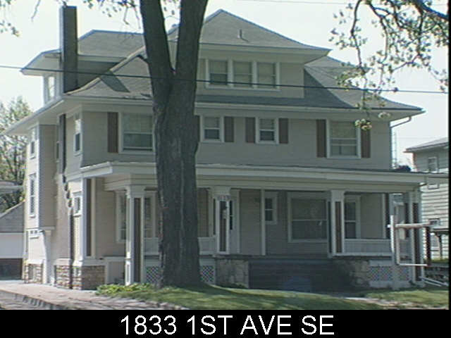
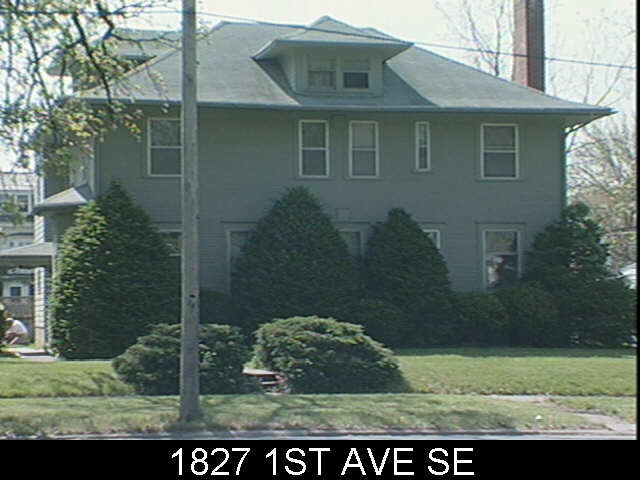
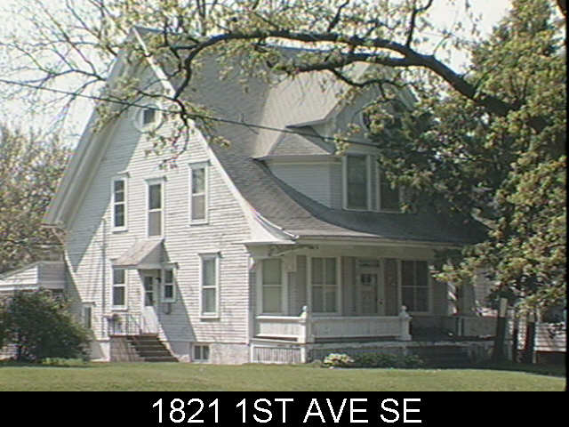
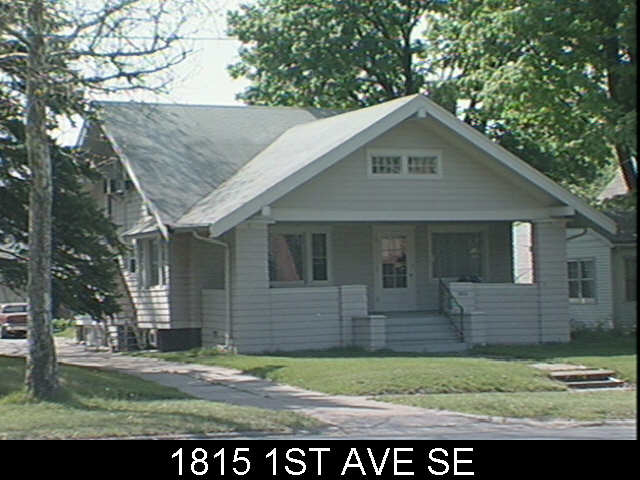
Green space was plentiful throughout the progressing development. A large Central Park is complimented by meandering greenways and tiny neighborhood parks. Streets are pretty much laid out in an efficient grid system with occasional deviation. Different areas sport different housing types and styles. Most are based on regional and traditional precedents and are all oriented toward the public street. Prices range from $80k townhouses up to $900k estate homes – view them all.

Stapleton brings back the alley, providing access to garages behind the houses. The fronts of these homes are no longer dominated by garages for cars, but porches for people. Most of the homes sit on compact lots so garages take up much of the back yard, so the front yard and neighborhood park spaces become the place for outdoor recreation and relaxation. This is believed to foster community and more interaction with neighbors.

Sustainability
Sustainability is a key focus of the new Stapleton neighborhood. Tangible measures include building all ENERGY STAR homes that are more energy efficient, some with solar panels; LEED certified office buildings; and recycling old runways and parking lots into new streets, bike paths and sidewalks. Additionally, nearly 27,000 new trees have been planted in Stapleton, and the new Central Park, greenways, and pocket parks have increased the amount of parkland in the city by over 30 percent.

Sustainability is not only about energy efficient buildings, but also planning, diversity of uses, and aesthetics that promote sustainable lifestyles and community. As mentioned above, streets are pretty much laid out in a grid system and connect at many points with the existing city road network. This is more efficient than the typical suburban road hierarchy of cul-de-sacs and short local streets feeding into collector streets and major arterials. Typical suburban subdivisions provide only one or two routes in or out, often making one walk or drive a longer distance due to convoluted curving roads and lack of thru streets. They also cost cities more to maintain because each street only serves a small number of residents. So grid street systems provide more direct access and route alternatives, distribute traffic more evenly, permit more efficient distribution of utilities and services, and minimize maintenance of excess roadways by maximizing the use per person of each street.

Proximity to places of work, stores, restaurants, and schools is also essential for a neighborhood’s sustainability. This reduces the need to drive so much for everyday needs and conveniences. Generally amenities within half a mile is an acceptable walking or biking distance.

Mixed Use and Retail
With over two million square feet of retail planned when completed, the Stapleton neighborhood certainly has a mix of amenities and residential. However, pretty much all the retail and commercial has been developed (and is planned for, according to Stapleton land-use maps) on the western edge near Quebec Street, so it is not as integrated with housing as it could be. Also a majority of the current retail is in the form of a dressed-up big box power center and a lifestyle center / mall, essentially your typical upscale suburban shopping center.

Current commercial and retail space is concentrated in three distinct main shopping districts. East 29th Avenue Town Center is the quintessential “main street” area so commonly found in New Urbanist developments. It is a relatively small area located on the west side of Stapleton along Quebec Street. Pedestrian scale one to two story shops and buildings are built up to street like a traditional downtown Main Street, with plenty of parking concealed in the back. This particular retail area is well connected to the new residential blocks, some right across the street. 29th Ave Town Center is at a main entrance into Stapleton along Quebec Street so it is able to serve both the newer residents of Stapleton and those of older existing neighborhoods across the street.

Another, less pedestrian retail area is Quebec Square, just north of the E 29th. Ave Town Center area on Quebec Street. It is a typic big box power center with Walmart, Sam’s, Home Depot and several national retailers and quick service restaurants. Although clearly car-oriented, there does seem to be effort made to maintain a grid of streets through the center and minimize the visual and physic disruption of massive parking lots by locating most buildings at corners and along the edge of roads. Despite it’s suburban nature, Quebec Square is still reasonably accessible from housing in the Stapleton neighborhood with connections via the street grid sidewalks – longer than a 5 – 10 minute walk for most residents, but quick trips could easily be done via bicycle.

One more major retail area is Northfield Stapleton, an open-air, lifestyle center shopping mall about a mile north of the center of Stapleton on the opposite side of Interstate 70. Following the trend, Northfield provides a faux Main Street shopping environment with decorative streetscaping and pedestrian scale store fronts. This is deceiving as the entire perimeter is surrounded with a massive parking lot and outlaying box stores. In satellite view, it appears the street ways through Northfield were designed for future expansion in mind – so the pedestrian storefronts could eventually extend beyond the original main street. Unfortunately these pedestrian friendly arteries will always end in a car-friendly parking lot. Despite the distance, there is no real direct pedestrian access from the residential areas of Stapleton to Northfield so inevitably even nearby residents will have to drive here.

One last retail center on the eastern edge of Stapleton is yet to be developed. Eastbridge Town Center, planned at the intersection of MLK Jr. Blvd and Havana Street will be 29th Ave’s counterpart. So eventually the residential core of Stapleton will be flanked by two pedestrian friendly commercial zones.

Walkability
Stapleton seems to be very walkable with appropriate pedestrian provisions and will only get better as the neighborhoods are filled in. However, my initial reaction was that residential areas were too segregated from commercial areas. I figured it’d be much more integrated and mixed. The distance between many homes and shopping would require at least a 10-15 minute walk one way, not bad, but perhaps not enough to keep someone from driving instead if the errand was urgent enough. A quick trip could be made by bike or frequent transit service though.

Transportation
Connectivity to the rest of Denver is also critical for the sustenance of Stapleton, as many residents are employed outside of the neighborhood. The neighborhood’s transit plan is pretty extensive with a bus hub planned with numerous direct routes to major employment centers throughout the metro. The future RTD train service to Denver International Airport will go through Stapleton, providing a direct connection to Denver’s expanding light rail system. See maps for more information about the neighborhood transportation and land use.

Lowry Neighborhood
Another mixed infill neighborhood was underway in Denver a year before Stapleton Airport even closed. I discovered Lowry, less than a mile south of Stapleton, on Google Maps, as they appear very similar in aerial plan view. Lowry is smaller than Stapleton at only about three square miles, on the former site of Lowry Field and Air Force Base. From quick Googling, it seems Lowry may be a bit more suburban in form than Stapleton, but still much improved over typical suburban housing. At about 80 percent build out, completion of Lowry is expected within a year.

All photos in this post are from Flickr user faceless b / EPA Smart Growth.

> Discover Stapleton (official website)

© 2022 URBAN THINKING

Theme by Anders NorenUp ↑