Tag: neighborhood

Piazza di Santa Maria Liberatrice

_DSC0432.JPG

It was a delightful sunny Saturday afternoon in Rome, following a bit of a dreary, but relatively warm morning. After lunch my friend Jenna and I decided to enjoy the nice weather with gelato in a park. We went to one of my favorite parks I’ve seen so far, Piazza di Santa Maria Liberatrice in the Testaccio neighborhood just across the river to the south of Trastevere. The neighborhood is relatively small, sandwiched between the Tiber to the west, the Aventine Hill to the east and Monte Testaccio (Rome’s ancient Mount Trashmore) and old industry to the south. The area was sparsely populated with poor rural settlements before the mid to late 19th century when it was developed for worker housing for the industries nearby. It is one of the few cases of planned urbanization in Rome.

Laid out in a grid system, the neighborhood has a sense of continuation within and with the rest of the city, despite actually being somewhat tucked away. The regular streets disguise the neighborhood’s small size, giving a sense it could continue endlessly. It is characterized mostly by 6-8 story apartment buildings with sidewalk level shops, a market building, one large early 20th century church Santa Maria Liberatrice, and of course its associated piazza.

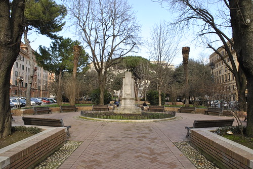
Piazza di Santa Maria Liberatrice is really more of a park compared to a typical Rome piazza. It is two blocks long and triangular shaped with a large playground at the wide end and a large open plaza in the center that flows into a brick pathway lined with benches leading to the narrow end near the church. The entire piazza is filled with trees and areas of green. The few actual grassy areas are separated by small grade changes with brick retaining walls and benches, discouraging walking there, so they have actually been maintained pretty well compared to most places with grass in the city. The abundance of trees and breaking up the piazza with different elements create several smaller spaces instead of one single open space which is more typical of Roman piazzas. This makes the piazza much more versatile and useful for more and different people. The scale and aesthetic of the buildings surrounding the piazza provide a well defined edge around the urban space.

After we got our gelato from a place at the corner, we took a bench in a nook between the playground and the larger central plaza. The playground was very active today with several children and their parents out enjoying the nice weather. Across from us three old men were sitting and shooting the breeze over a smoke. Soon several of the local pigeons congregated around us as we were finishing our cones. I laid a few crumbs down near me to see how close they would come. One little guy in particular was trying to get closer but kept beating around the bush. A small lonely sparrow came out from his hiding spot under a bush so I threw him (or her) a piece.

Later on a few boys started of a game of soccer in the central plaza space – the biggest kid as the goalie. Meanwhile the old men went on their way and a new crew took their place. The mini world cup was a fierce match but all in good fun. When the ball went astray there was plenty of help getting it back. A middle aged man sitting on the bench next to us tossed it back first. Then a young father passing through with his daughter in an all-terrain stroller kicked it back to them. The next foul ball went high into the air right towards the new group of old guys. I can only imagine the brief terror those kids experienced as the ball went hurling through the air towards them. But the men shrugged it off and all was well. It was a captivating game that got everyone involved.

The interaction of different people, different generations, and different creatures makes visiting this park a wonderful experience. It is a park that encourage and facilities an endless number of activities through its design and amenities like the playground and ample sittable space. The different spaces within it are at a human scale, making them inviting and comfortable to be in. The buildings and church that frame the park give it context and a sense of place, making it special and unique to that community. Piazza di Santa Maria Liberatrice is everything a great urban neighborhood park should be – and a great place to enjoy the day with some gelato.

Imagine a Vital Neighborhood Cedar Rapids

Cedar Rapids-based, non-profit organization S.E.E.D. (Sustainable Ecological Economic Development) will be hosting a Sustainability Symposium “Imagine a Vital Neighborhood” this Saturday with architecture grad students from Iowa State University. Students will present design proposals to stimulate ideas for building a pedestrian friendly, sustainable neighborhood in the Oakhill Jackson and New Bo areas near downtown Cedar Rapids.

S.E.E.D. founder and Oakhill Jackson Neighborhood Association President Michael Richards has been collaborating with the College of Design’s “Bridge Studio” for two years. The first year students developed prototype designs for post-flood affordable housing that received the grand prize for the 2009 NCARB Prize for Creative Integration of Practice and Education in the Academy. Professors Clare Cardinal-Pett, Peter Goche, and Nadia Anderson, who was my studio instructor this past fall, will be leading the event.

Anyone interested in the revitalization of these neighborhoods and making a more livable, sustainable Cedar Rapids is encouraged to attend. The forum will be held from 10am – 5pm, this Saturday, Jan. 23, at the Community Conference Hall in the Horizons Building, 819 5th St. SE. More information about the event can be found on BJ Smith’s Puncture Proof blog.

> Bridge Studio
> S.E.E.D.
> Puncture Proof: Forum promotes pedstrian-friendly neighborhoods

CR Neighborhood Planning Workshop

Today I participated in the second of three community workshops for the Cedar Rapids Neighborhood Planning Process for the River Corridor Redevelopment Plan. The focus of today’s workshop was on transportation and connectivity, and land use in the redevelopment plan. Individuals from Sasaki Associates, the Boston design firm selected last year (pre-flood) to develop a riverfront redevelopment plan, were there to present different scenarios and facilitate discussion.

The first breakout session was to discuss the strengths and weaknesses of three scenarios presented on transportation, connectivity and open space. All scenarios were based off a tentative plan for a greenway / flood protection system. The second breakout session considered land use and locations to focus housing and business revitalization. My table was fairly diverse – one older man, a retired woman formerly a planning consultant, two women from Time Check, one of their daughters; and our table leader, a planner with the City Community Development Department.

Turn out looked pretty good, maybe 150-250, but I could be way off. I saw a lot of familiar faces from City Hall and in the business community. I thoroughly enjoyed the sessions and hearing what other citizens had to say about the schemes, as well as offer my own input. Despite being six hours long, it seemed to go by pretty quickly and was actually really pretty fun for me. I look forward to participating in the next meetings I’m able to make it, as I’ll be returning to Ames tomorrow for school.

The next meeting will be Tuesday, March 31, from 6pm – 9pm, at the Crowne Plaza, for scenario evaluation and determining a preferred scenario. The last of three workshops will be April 25. An action plan will be confirmed at a May 5 meeting and will be presented to the City Council on May 13. I encourage anyone and everyone from Cedar Rapids to get involved in this process.

> Cedar Rapids River Corridor Redevelopment Plan
> Cedar Rapids Neighborhood Planning Process
> Sasaki Associates: Cedar Rapids River Corridor Redevelopment Plan

Welcome to Stapleton

When I was in Denver about a month ago, I took a short driving tour around the newly established Stapleton neighborhood, a massive redevelopment project underway at the former site of Stapleton International Airport. The largest New Urbanism project in the United States (according to Wikipedia), Stapleton is designed to be a more sustainable, community-oriented, mixed-use neighborhood. I was eager to check out the progress.

Housing and Public Space
Green space was plentiful throughout the progressing development. A large Central Park is complimented by meandering greenways and tiny neighborhood parks. Streets are pretty much laid out in an efficient grid system with occasional deviation. Different areas sport different housing types and styles. Most are based on regional and traditional precedents and are all oriented toward the public street. Prices range from $80k townhouses up to $900k estate homes – view them all.

Stapleton brings back the alley, providing access to garages behind the houses. The fronts of these homes are no longer dominated by garages for cars, but porches for people. Most of the homes sit on compact lots so garages take up much of the back yard, so the front yard and neighborhood park spaces become the place for outdoor recreation and relaxation. This is believed to foster community and more interaction with neighbors.

Sustainability
Sustainability is a key focus of the new Stapleton neighborhood. Tangible measures include building all ENERGY STAR homes that are more energy efficient, some with solar panels; LEED certified office buildings; and recycling old runways and parking lots into new streets, bike paths and sidewalks. Additionally, nearly 27,000 new trees have been planted in Stapleton, and the new Central Park, greenways, and pocket parks have increased the amount of parkland in the city by over 30 percent.

Sustainability is not only about energy efficient buildings, but also planning, diversity of uses, and aesthetics that promote sustainable lifestyles and community. As mentioned above, streets are pretty much laid out in a grid system and connect at many points with the existing city road network. This is more efficient than the typical suburban road hierarchy of cul-de-sacs and short local streets feeding into collector streets and major arterials. Typical suburban subdivisions provide only one or two routes in or out, often making one walk or drive a longer distance due to convoluted curving roads and lack of thru streets. They also cost cities more to maintain because each street only serves a small number of residents. So grid street systems provide more direct access and route alternatives, distribute traffic more evenly, permit more efficient distribution of utilities and services, and minimize maintenance of excess roadways by maximizing the use per person of each street.

Proximity to places of work, stores, restaurants, and schools is also essential for a neighborhood’s sustainability. This reduces the need to drive so much for everyday needs and conveniences. Generally amenities within half a mile is an acceptable walking or biking distance.

Mixed Use and Retail
With over two million square feet of retail planned when completed, the Stapleton neighborhood certainly has a mix of amenities and residential. However, pretty much all the retail and commercial has been developed (and is planned for, according to Stapleton land-use maps) on the western edge near Quebec Street, so it is not as integrated with housing as it could be. Also a majority of the current retail is in the form of a dressed-up big box power center and a lifestyle center / mall, essentially your typical upscale suburban shopping center.

Current commercial and retail space is concentrated in three distinct main shopping districts. East 29th Avenue Town Center is the quintessential “main street” area so commonly found in New Urbanist developments. It is a relatively small area located on the west side of Stapleton along Quebec Street. Pedestrian scale one to two story shops and buildings are built up to street like a traditional downtown Main Street, with plenty of parking concealed in the back. This particular retail area is well connected to the new residential blocks, some right across the street. 29th Ave Town Center is at a main entrance into Stapleton along Quebec Street so it is able to serve both the newer residents of Stapleton and those of older existing neighborhoods across the street.

Another, less pedestrian retail area is Quebec Square, just north of the E 29th. Ave Town Center area on Quebec Street. It is a typic big box power center with Walmart, Sam’s, Home Depot and several national retailers and quick service restaurants. Although clearly car-oriented, there does seem to be effort made to maintain a grid of streets through the center and minimize the visual and physic disruption of massive parking lots by locating most buildings at corners and along the edge of roads. Despite it’s suburban nature, Quebec Square is still reasonably accessible from housing in the Stapleton neighborhood with connections via the street grid sidewalks – longer than a 5 – 10 minute walk for most residents, but quick trips could easily be done via bicycle.

One more major retail area is Northfield Stapleton, an open-air, lifestyle center shopping mall about a mile north of the center of Stapleton on the opposite side of Interstate 70. Following the trend, Northfield provides a faux Main Street shopping environment with decorative streetscaping and pedestrian scale store fronts. This is deceiving as the entire perimeter is surrounded with a massive parking lot and outlaying box stores. In satellite view, it appears the street ways through Northfield were designed for future expansion in mind – so the pedestrian storefronts could eventually extend beyond the original main street. Unfortunately these pedestrian friendly arteries will always end in a car-friendly parking lot. Despite the distance, there is no real direct pedestrian access from the residential areas of Stapleton to Northfield so inevitably even nearby residents will have to drive here.

One last retail center on the eastern edge of Stapleton is yet to be developed. Eastbridge Town Center, planned at the intersection of MLK Jr. Blvd and Havana Street will be 29th Ave’s counterpart. So eventually the residential core of Stapleton will be flanked by two pedestrian friendly commercial zones.

Walkability
Stapleton seems to be very walkable with appropriate pedestrian provisions and will only get better as the neighborhoods are filled in. However, my initial reaction was that residential areas were too segregated from commercial areas. I figured it’d be much more integrated and mixed. The distance between many homes and shopping would require at least a 10-15 minute walk one way, not bad, but perhaps not enough to keep someone from driving instead if the errand was urgent enough. A quick trip could be made by bike or frequent transit service though.

Transportation
Connectivity to the rest of Denver is also critical for the sustenance of Stapleton, as many residents are employed outside of the neighborhood. The neighborhood’s transit plan is pretty extensive with a bus hub planned with numerous direct routes to major employment centers throughout the metro. The future RTD train service to Denver International Airport will go through Stapleton, providing a direct connection to Denver’s expanding light rail system. See maps for more information about the neighborhood transportation and land use.

Lowry Neighborhood
Another mixed infill neighborhood was underway in Denver a year before Stapleton Airport even closed. I discovered Lowry, less than a mile south of Stapleton, on Google Maps, as they appear very similar in aerial plan view. Lowry is smaller than Stapleton at only about three square miles, on the former site of Lowry Field and Air Force Base. From quick Googling, it seems Lowry may be a bit more suburban in form than Stapleton, but still much improved over typical suburban housing. At about 80 percent build out, completion of Lowry is expected within a year.

All photos in this post are from Flickr user faceless b / EPA Smart Growth.

> Discover Stapleton (official website)

© 2022 URBAN THINKING

Theme by Anders NorenUp ↑