Tag: Iowa (page 1 of 2)

Ames, Iowa

Another fall semester commences next week at Iowa State. After spending five years in Ames I graduated this past spring and am now working as an interim intern at my favorite CR design firm. While I enjoyed my time in Ames, I can’t say I’m too upset about not going back next week. The following, unfinished post might begin to explain why. Please excuse its incompleness, possible out-of-dateness, and the composition skills of a younger me.

“Reflecting on Ames: Lonely by Design”

I began writing this description of Ames back in December 2008. Finals were over at Iowa State and half the population of Ames had left. I stayed in town for a few days to work extra shifts at CyRide – only a few passengers riding my bus. In the middle of winter when students leave, Ames turns into a very empty and lonely place. I was living in Frederiksen Court north of campus at the time, which I always found to be disconnected from the rest of campus and similarly the city.

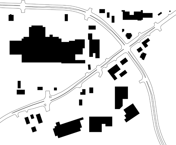
The whole city of Ames is physically fragmented and divided by greenspace surrounding Squaw Creek. The original city of Ames, where downtown is located, developed about half a mile east of the creek; but when Iowa State was founded, the campus was developed just to the westof the creek. While homes and businesses have been developed to the west of campus, and addition development has taken place to the north and south of the original city, a noticeable void in the middle still remains.

Ames map

Unlike the University of Iowa, which developed its campus right adjacent to downtown Iowa City, ISU was built in empty farmland, a mile away from town (after all it is an ag school). Because of this, Ames does not have the vibrant and unified, central downtown like Iowa City, but instead two, sort-of ok “downtowns” and no established “heart” of the community.

Lincoln Way, the main east-west drag through town, divides Ames into north and south. It owes its name to the original Lincoln Highway route, running right through the center of town (the modern Highway 30 is now a freeway on the south fringe of town), and was a major development and redevelopment force through Ames’ history. Around the university Lincoln Way is actually quite nice and walkable, but everywhere else it leaves much to be desired. To the east of campus, the road passes through vast open land of the Iowa State Center complex to the south, and intramural fields to the north near University Boulevard, before crossing Squaw Creek. Despite giving visitors the impression that Ames is a sparse, wasteland of meaningless greenspace and parking lots, University Blvd. is the designated gateway to Iowa State.

Along Lincoln Way, the southern edge of campus, is Campustown, a small business district and neighborhood that developed organically right to the south of campus in the late 19th through mid-20th century. Established storefronts line two or three blocks of Lincoln Way and about two, north-south blocks of Welch Avenue. Home to numerous bars, some places to eat, and a few miscellaneous stores and businesses, the neighborhood serves ISU well. Surrounding the commercial district are older houses – mostly used for student rental housing; fraternity and sorority houses, walk-up apartment buildings, and even a few apartment highrises. Mostly built in the 1990s, the highrises were not held to very strict design standards so they were built cheap, are unattractive, and while increasing the density of Campustown (good), it degrades the aesthetic and historic integrity of the area. A few years ago the City of Ames passed a moratorium on new highrises to preserve the historic scale and charm of the area, but an ordinance requiring better design would serve the area much better.

My appreciation for the walkability and mixed-uses in Campustown should not be understated, coming from my freshman year at North Dakota State, which lacked any established campus town area for students to gather and identify as their own. Campustown sustains vibrancy around campus into the evenings and late into the night on weekends. It grounds Iowa State as a place with people, with activity, with life. However the commercial area is relatively small and there is little activity when students are away. Locals tend not to frequent this area – not much to offer them besides the bars – so interaction between students and members of the community is generally limited.

A mile down the road is the real downtown Ames. It is certainly nice enough, but railroad tracks divide it from Lincoln Way to the south, creating a physical and mental barrier. With that, when driving or walking down Lincoln Way, it’d be hard to know you’re just a block from the city’s historic center, as auto-oriented businesses and the Lincoln Center shopping center has dominated this stretch of road for decades. Main Street is a well-kept stretch of continuous storefronts with some fine dining and specialty shops. There are a few taller buildings (maybe five or six stories max) in downtown. The tallest, most dominant structure in downtown is of course the Ames power plant, situated across Duff Ave at the eastern terminus of Main Street, literally the end of town.

Away from Main Street, buildings are spaced out as many historic structures have been demolished over the years for parking and ugly bank buildings. The combination of open lots, railroad obstacle, and literally being just blocks from undeveloped land, downtown has a certain vulnerable feeling to it. It is exposed. Except to the north where it flows fairly harmoniously into a historic residential area, downtown seems cut off to the rest of town, especially its most active arterials (ie. Lincoln Way). Downtown is never visibly very active and the fragmentation of former built-up, urban density does little to create a cohesive, continuous, united-feeling city center.

Ames’ main big box commercial strip is South Duff Ave between Highway 30 and Lincoln Way. Right on the edge of town, the backsides of most businesses face cornfields. Big box destinations include: Target, Super Walmart, Best Buy, Kmart; and south of 30 are Lowes and Sam’s Club. The whole stretch is a mismatch of old remaining sheds and non-retail commercial buildings, next to newer, cheaply built chain stores and restaurants. Most of the big boxes are located far away from the street with enormous parking lots in the way. Some fast food outlets and strip buildings are closer to the road but there is no continuity or consistency. The great distances between buildings and lack of any real massing of building by the road make it feel insecure and aesthetically awkward. Decorative, almost pedestrian-scaled street lamps line the street, but do little for walkers when there isn’t even a continuous sidewalk on either side. And don’t even think about direct pedestrian paths from the street to entrances of stores and restaurants in places a sidewalk does exist – that would certainly be too much to ask.

Honestly the most, consistently active place I know is inside North Grand Mall. Located at the north edge of town, mostly surrounded by medium and low density residential, the mall is not physically well-kept, but maintains decent occupancy and mid-level retailers because it’s the only one in town (though a new “lifestyle center” mall is supposedly in the works at I-35 and E 13th Street). To compete with the new mall, North Grand is proposed to undergo a major renovation that will transform the entire south end (former Sears and Walgreens location) in to an outdoor, mini lifestyle-center adjacent to the spruced up existing indoor mall. Despite being announced well over a year or two ago, little has happened with either shopping center development. One glimmer of hope, though – a new, stand-alone Walgreens has been built at North Grand as an outparcel by the main entrance. This opens up the old attached Walgreens space, with the already vacated Sears store to make way for the “Shops at North Grand.” Regardless the new Walgreens is an attractive building and fills part of the long spatial void of the parking lot along Grand Ave.

Also in the area – a Wal-Mart and Cub Foods are located north of the mall. Further north is a small strip mall with a terrible name, “The Northern Lights Center.” The commercial buildings are generally surrounded by inexpensive apartment complexes, duplexes, and then flows back into single family neighborhoods.

[This post was never finished…sorry]

City Updates – July 6

More news and views from Cedar Rapids:

Freedom Festival
The Freedom Festival fireworks returned to downtown this 4th of July, after a two year hiatus following the flood of 2008. It was great having the fireworks back downtown, but unfortunately they were launched from the green space on Mays Island, rather than a small barge as in years past, so the island and both 2nd and 3rd avenue bridges were closed off to spectators. Mays Island and the two bridges have long been center of fireworks festivities with food vendors lining the bridges and a band stand set up on the green. It is one of the only times our civic island is actually used anymore. Most days it sits empty and lifeless, extending the divide between our east and west, rather than uniting them through a grand civic park it once was.

According to Russ Oviatt, Freedom Festival operations director, “The launch site change was necessitated after the existing barge arrangement that had been used for a number of years was no longer an option.” No explanation for why the barge is no longer an option, but it sounds likely this will be the case from now on.

From Freedom Festival executive director Janet Wilhelm, “It’s not unexpected that even though the Celebration of Freedom fireworks are returning to downtown Cedar Rapids this year, it will take several years to establish a new “traditional” downtown venue.”

I hope another launch site can be found in downtown. Cedar Rapids undoubtedly has one of the best fireworks celebrations in the region – it would be a real shame to stop taking advantage of our unique island venue, that has united east and west neighbors on the 4th of July for years.

In other fireworks news, the Ellis Fireworks also returned this year, put on by the Cedar Rapids Boat Club. The annual display traditionally held on July 3 near Ellis Park along the Cedar River, was postponed in 2008 following the flood and was cancelled in 2009 due to ongoing flood recovery efforts in the surrounding neighborhood.

Czech Village Roundhouse
Business leaders in Czech Village hope to raise over $2 million to rebuild the Riverside Roundhouse, elevated on a new concrete-deck with parking underneath. The Roundhouse was built in 1962, in Czech Village and used for a farmers market until it was moved downtown in 2007. Following the flood neighborhood business owners dismantled the steel structural skeleton and put it into storage with intentions to reconstruct it someday. The former site will now be occupied by the National Czech and Slovak Museum building, which will be moved and elevated from its current adjacent site, on the banks of the Cedar River between 12th and 16th avenues SW.

Proposed Czech Village Roundhouse, from Ament, Inc.
Czech Village Roundhouse rendering by Ament, Inc.

The proposed new Roundhouse site is at 17th Avenue and B Street SW, which is to the south behind the main commercial strip of 16th Avenue between A Street and C Street SW. The proposal, devised by Ament, Inc., would place the reconstructed Roundhouse atop a 14,400 square foot concrete deck with parking space for 24 cars underneath at ground level. The rendering above, created by Ament, Inc., shows the proposal. Business owner Alex Anderson who is spearheading the fundraising effort says the building will be used for Czech Village events and hopes to be completed by 2012.

I am not against this project, but I question its feasibility and cost-benefit. While saving the Roundhouse is a noble venture, it seems unreasonable to spend that much money to elevate a building that is little more than a steel skeleton with a minimal interior finish. Construction of the concrete deck for the building to sit on would constitute the bulk of the $2 million cost, and an elevator to make it universally accessible would cost $250,000, according to the Gazette.

An alternative would be to reconstruct the Roundhouse at grade (even built up a few feet) with awareness of potential future flooding. This would eliminate the enormous cost of the concrete deck and the need for an elevator (which would be affected by flooding regardless). Think of what else that same amount of money could be spent on in the village. Read more on the Gazette.

Mexican Restaurants Downtown
The history of the Brosh Funeral Home and Chapel building in New Bohemia became clearer last week when 83 year-old Harvey Viall came forward with his story and photos of working at the building in the early 1950s when it was a station for the Denver-Chicago Trucking Company, which had transported weapons and other goods for the military during World War II.

Two weeks ago the owner of Papa Juan’s/Stefano’s announced he wants to open a new Mexican restaurant in the building, but cannot afford to without historic tax credits and exemption from raising the building above the 2008 flood level, which would only be available if the building is granted “contributing” historical status. A new application is now being sent in for historic status based on its connection to World War II. If approved, plans are to invest $900,000 in renovations and have the new restaurant open for business within four months of obtaining permits. Read more here from the Gazette.

Further north in downtown, another new Mexican restaurant is planned for ground floor space in the Berthel Fisher & Co. building at the corner of First Avenue and Second Street SE. La Cantina will open just a few doors down from the long-standing Gringos Mexican restaurant on First Avenue. A new restaurant here is positive news for improving the vitality and activeness of downtown.

First Street Parkade
The nearly 50 year-old First Street Parkade downtown will be demolished soon. Read more at Urban Corridor.

Flood Anniversary

This weekend marks the two year anniversary of the 2008 floods that caused destruction across the Midwest and inundated downtown Cedar Rapids and hundreds of city blocks encompassing the older neighborhoods of Time Check, Czech Village, New Bohemia, Rompot, Taylor, and parts of Oakhill-Jackson. The bulk of the event took place on Thursday, June 12 to Friday, June 13, and took out nearly every municipal, county, and federal government buildings along with thousands of individual homes and businesses.

I’m reposting my “one year later” post that I wrote last year that described my experience with the flood working at the Veterans Memorial Building on Mays Island, which was severely flooded.

The Flood – One Year Ago
One year ago today, on Wednesday, June 11, 2008, historic flooding was underway in Cedar Rapids. My third summer as a seasonal employee with the Veterans Memorial Building maintenance crew, I had a very involved, first hand perspective of the flood in downtown and public facilities. Working at the Veterans Memorial Building, better known as City Hall, which sits on Mays Island in the middle of the Cedar River in downtown Cedar Rapids, I watched the river rise daily and got regular updates and break room commentary on surrounding areas from my elder co-workers who lived outside the city. I remember watching the river rise through downtown the previous summer so up until the day or two before, it really didn’t seem like it was going to be that big of deal. Of course, official crest predictions continued to go up, and an additional downpour that Thursday pushed the river to crest at an absurd 31+ feet, breaking the old record by almost ten feet. Even during the flood and immediately after, I didn’t seem to grasp the enormity of its affect. Originally I figured we could be back in the building clearing out and cleaning up within a few weeks and have the building back up and running. Who would’ve known it’d be a year later, the lower levels cleared out and down to bare-bones, with little more than a possibility of the City offices one day returning.

Preparation at Vets Memorial
At work, the greatest day of urgency was on that Wednesday, June 11, the day before the building and much of downtown were completely overtaken with water. I recall arriving to work around 8am as normal. I walked from the GTC, where I commuted to by bus, past the riverwalk along the eastern bank of the river. The river level had began to rise above the lowest part of the walk, near 4th Avenue. Smulekoff’s, which sits directly next to the river, was clearly taking on water with a number of hoses from the basement pumping it back into the river. Water was also being pumped out of the underground Mays Island parking garage, which had begun to seep in a day or two before. This morning the river level was inches from topping the river wall lining the mid park section of the island and only four or five feet from the road beds of the three bridges.

Underground floodingAs I got into work, water had already begun to seep through the walls of the “underground” – an addition built underneath Second Avenue in the 1960s which connects the basement of the original structure to the underground parkade, also constructed at that time. Originally the location for emergency management and various other offices, the space had been condemned for a number of years due to falling pieces of concrete from the ceiling (below the street), and was essentially a large, half-demoed space used for storage, trash, and recycling sorting. Attempts to block or patch the wall seepage were no good and water quickly began flowing into the public hallway through the underground. We set up some sandbags by underground’s connection to the original building and set up a hefty pump to try to keep it down.

Throughout the day city office workers from upstairs were carting boxes of city legal records and other documents stored in the basement up to the auditorium on the first floor – which of course, turned out to be in harm’s way anyway as the final crest was two feet above the first floor.

I took two or three trips to Public Works in the dump truck to pick up pallets of sandbags that day. Volunteers were working around the clock filling sandbags for city and private use. I had trouble even getting in with the line of cars waiting to get their ten alloted sandbags. City vehicles were able to drive in to be loaded with full pallets. While in line one a woman was handing out free pizza and told us to “Keep up the good work.” As the situation worsened, cooperation and morale ran high.

Returning to the building with my first load, just about noon, I encountered heavy traffic. Congestion around public works and downtown as people rushed to prepare homes and businesses, along with the closure of the 3rd Avenue bridge made a normal five minute trip, take more like 20 or 30 minutes. It had begun raining at that point, making the enduring flooding seem even more dire. When I finally made it to the First Avenue bridge, I pulled into the east alley by the building and started unloading the sandbags around a basement window opening before breaking for a quick lunch in the shop.

Rain clouds cleared in the afternoon as work continued. Lots of people were downtown – many came as onlookers, and many came to help. Two guys who were walking by helped us unload another truck load of sandbags in front of a west side entrance to the mezzanine level. Back to public works for another load – surface level flooding becoming much more apparent in low areas a few blocks from the river. On my last trip back to Mays Island, police were diverting westbound First Avenue around 6th Street West due to water now over the road (in lower areas, not all the way from the river). I was allowed to go through as I was just going to City Hall.

Towards the end of my work day I helped the two night guys move supplies from the basement up to the dining room on the mezzanine level – again a futile effort as this room was entirely submerged the next day. Before leaving the building around 5pm, I went to the roof to get some pictures of the river flooding from all angles. At this point the 3rd Avenue bridge had been closed as water was but a foot from the road bed now. 2nd Avenue bridge was closed about an hour later. Eventually all river crossings in the city were closed except for I-380.

The Crest
The next morning, Thursday, June 12, it was raining hard. I had planned to go into work early but the building and much of downtown had already been completely inundated. That day, at home, we had to deal with rain-related water coming into our basement. My brother Daniel was also hurrying to move guitars and equipment from his recording studio about seven blocks from the river – just in case. He and his business partner had just signed a lease for a larger, more permanent space in downtown Marion so they simply moved much of it to their new location. I went along to help them out in the afternoon as rain was still coming down – and the river still rising.

After finishing up we decided to walk a few blocks toward the river where the water had now reached past the 4th Street railroad tracks in the downtown core. Many National Guard officers were on the scene keeping the public away and out of the water as volunteers continued sandbagging buildings close by. We didn’t stick around very long.

The next few days were to watch and wait. Many businesses outside of downtown were closed as accessibility throughout the city was extremely hampered with 380 being the only river crossing for days. With three of the city’s four collector wells being flooded, conserving water was also critically important. Most businesses and residents obeyed mandatory water restrictions, refraining from doing laundry and showering for days. The Cedar River finally crested at around 31 feet early afternoon on Friday, June 13, taking thousands homes and hundreds of city blocks.

Pretty much confined to the house as my summer job was under water and most businesses remained closed, that Sunday was a less than average Fathers Day, I imagine, for most of the community’s dads. My brothers and I went to see our dad that afternoon out at Kirkwood, where he had spent the past few days reporting news on the flood at KCCK radio. This was my first time crossing the river since the floodwaters had submerged much of downtown, and certainly Mays Island. Though water had already recessed a number of feet, the view from 380 was no doubt dramatic.

Post Flood Clean Up
I finally returned to work the following week on Tuesday, the 17th, meeting my VMC co-workers at the Police Station to start picking up sandbags and debris, along with some guys from the city parking division. As transit serve had not resumed yet, my mom gave me a ride there. After passing a checkpoint many blocks from the station, we drove down blocks of empty streets surrounded by empty houses and no people. It was very surreal.

All downtown bridges were reopened and transit service resumed Wednesday, the 18th, with limited service so I took the bus to work. A temporary transfer site was set up at 4th Ave and 12th Street SE, and buses were not allowed to pick up or drop off any passengers inside the still access-controlled flood zone. Since I was to report back to the police station, they allowed me off with a show of my city badge. With the same crew from the day before, we finished picking up sandbags at the station and then headed across the river to pick up bags at the public library. Private clean up crews were already well underway at the Great America Building across the street and downtown was beginning to buzz as debris piles began filling the curbs.

A few days later my first return to the building was to help take photos of damage. We entered through a side door to the mezzanine off the loading dock ramp. Our view as we entered can be seen in the photo below. Everything inside was covered in mud, plaster and paint falling off the walls, and an unrecognizable darkness. Water still had not receded out of the basement so the mezz was as far down as we could go. Up on the first floor, which had taken on about two feet of water, the old wood auditorium floor was completely ruined as were many artifacts in the Spanish American War Memorial room that served as the VMC office.

Over the next few days as water went down to a foot or two in the basement, we recovered the gas pump we had been using the previous and set it up to pump out the remaining standing water. We now had a couple state troopers for 24/7 security, as we took turns “watching the building” – essentially just refueling the pump whenever it ran out. I spent many long days just sitting by the First Avenue doors watching the cars go by.

Not surprisingly, it took at least a week or two for professional cleanup crews to start picking up Vets Memorial, while many other buildings were already underway. Although I was not in position to actually do any cleanup work, they did need someone from our department there at all times as a go-to person and to unlock and lock the building at the beginning and end of the day. Like watching the pump, many afternoons, evenings, and Saturdays were spent simply sitting around at the building. I got to know our regular Per-Mar security gang, which replaced the state troopers as security. Other than that, the night crew and I spent much of the rest of the summer out at Veterans Memorial Park, by the stadium, which is also owned by the Vets Commission.

After returning to Ames this past year for school, I tried to keep up with recovery news from the Gazette and other sites, but it was hard not to disconnect from the flood. With the few days I was back in town for Thanksgiving and Christmas it was hard to gauge the progress. At spring break time in March, downtown had been pretty well cleaned up and many major businesses had returned. But work continues for smaller businesses and other less visible areas, like New Bohemia, Czech Village and Time Check.

Figure Ground Development Patterns

Figure-ground diagramming is an interesting and useful tool for analyzing spatial relationships in urban environments. It also provides a striking comparison of density and land use of older urban development compared to more contemporary suburban development. In older, urban places buildings typically took up the majority of space on a city block so even when diagramming built structure as figure (black) and space without structure (ground) the graphic would essentially depict the street grid. In more contemporary development however, auto-centricism has made for much more spread out buildings divorced from the street edge. Instead of relating to the street and sidewalk (if there even is one), these buildings related to their respective parking lots. Figure-ground diagrams of these sorts of places are often difficult to discern where roads actually go, but are very telling at the amount of open space wasted on the temporary storage of cars.

The figure-ground diagram above is an example of one of these suburban places that lack order and urban spatiality. They vast openness surrounding the buildings makes it hard to tell where roads go or even scale. The variety of building orientation in this case makes it even more difficult to decipher. In the image below, the roads are included, and we can begin to understand more about this space.

The diagram shown is of the Lindale Mall area in northeast Cedar Rapids, where First Avenue and Collins Road intersect. First Avenue is the road running diagonally from the lower left-hand corner up to the top right. I first decided to explore this area through figure-ground after noticing the actual corner of First Ave and Collins is very undefined. In fact, hardly any of the buildings in the study area relate in orientation or proximity to the street at all.

In the image below I stitched together multiple bird’s eye views from Bing Maps. The predominance of pavement stands in stark contrast with the lush green, tree-laden land to the south. The awkward angles at which big box stores were built, situated far from the street, combined with sloping terrain, makes for a very haphazard, almost disorienting, landscape. Driving along First Avenue, the only thing definite is that you are constantly surrounded by parking lot. Asphalt abuts the street the entire length, with only a few small outparcel structures even nominally close.

The area began developing in the 1960s, following the construction of Lindale Plaza, later enclosed as the indoor mall it is today. Besides Lindale, most of the larger scale retail developments there today were only built in the last ten years or so, as older properties were redeveloped. These recent redevelopment areas comprise a significant amount of the First Avenue corridor, and every single one disregards site context and has little relationship to the street. How unfortunate since these will ultimately remain for at least the next few decades.

So why is this a problem? The chaotic development pattern makes finding particular businesses – especially while driving – more difficult, and is very inconvenient for pedestrians. Even if the area had a complete sidewalk network, going from place to place would take much longer on foot than if buildings were closer to the road. I also don’t think massive parking lots make for a very attractive street environment.

Now I’m not advocating no parking, but what if the placements of all these buildings were simply switched with their respective parking areas? If buildings were located by the street and parking placed in the rear, it would be more accessible and equitable to those arriving on foot, bike, or bus – while still serving car customers just as well. With buildings all along the street, it would reduce the distance between places, making it easier for people to get to multiple stores and restaurants in the area on foot. In the current setup, it’s likely most people will get back in their cars just to drive over to the next store rather than walking.

Aesthetically, the street would be much more attractive with a well defined edge. This would provide the area a stronger sense of place and urbanity, instead of the anonymous suburban scape that exists now. Distance-wise, the mall and surrounding development is really quite close to a large residential area, just a few blocks down First Avenue, but right now there’s not even a sidewalk from around 40th Street up until the mall, where then, there is only a partial sidewalk along the south side in front of Home Depot. Even so, if a continuous sidewalk existed, psychologically the perceived distance from nearby homes would be quite long due to the spread out configuration of buildings. Built-up density makes walking distances seem shorter, while vast open space – like parking lots – makes distances seem longer.

If newer buildings like Home Depot and Marketplace on First had been built up to the street, this area would already look and feel more dense and closer together. With a more urban scale, nearby residents may find walking or catching the bus (pending improved transit service) to be more convenient than driving the five or six blocks to the mall. Unfortunately the current setup encourages and almost necessitates driving.

I don’t expect this area to ever drastically change, especially since many of these developments are relatively new, but I do hope that other new large and small scale commercial developments will be more respectful of the street and accommodate customers arriving by all different modes equally. Urban design is not only about how the environment looks, but about how it is organized, oriented, scaled and proportioned. Good urban design can have a profound impact on the accessibility, usability, and sustainability of new developments.

Neighborhood Reinvestment Action Plans published

The Cedar Rapids Neighborhood Reinvestment Action Plans have been published on the Corridor Recovery website. This plan was developed by Sasaki Associates with a great deal of community input through the Neighborhood Planning Process during the first few months of 2009. It was approved by the City Council on May 13, to guide short and long term redevelopment in flood-affected neighborhoods. The final action plan includes a specific set of tasks to be completed that will compliment comprehensive goals.

> Neighborhood Reinvestment Action Plans

The Flood – One Year Ago

One year ago today, on Wednesday, June 11, 2008, historic flooding was underway in Cedar Rapids. My third summer as a seasonal employee with the Veterans Memorial Building maintenance crew, I had a very involved, first hand perspective of the flood in downtown and public facilities. Working at the Veterans Memorial Building, better known as City Hall, which sits on Mays Island in the middle of the Cedar River in downtown Cedar Rapids, I watched the river rise daily and got regular updates and break room commentary on surrounding areas from my elder co-workers who lived outside the city. I remember watching the river rise through downtown the previous summer so up until the day or two before, it really didn’t seem like it was going to be that big of deal. Of course, official crest predictions continued to go up, and an additional downpour that Thursday pushed the river to crest at an absurd 31+ feet, breaking the old record by almost ten feet. Even during the flood and immediately after, I didn’t seem to grasp the enormity of its affect. Originally I figured we could be back in the building clearing out and cleaning up within a few weeks and have the building back up and running. Who would’ve known it’d be a year later, the lower levels cleared out and down to bare-bones, with little more than a possibility of the City offices one day returning.

Preparation at Vets Memorial
At work, the greatest day of urgency was on that Wednesday, June 11, the day before the building and much of downtown were completely overtaken with water. I recall arriving to work around 8am as normal. I walked from the GTC, where I commuted to by bus, past the riverwalk along the eastern bank of the river. The river level had began to rise above the lowest part of the walk, near 4th Avenue. Smulekoff’s, which sits directly next to the river, was clearly taking on water with a number of hoses from the basement pumping it back into the river. Water was also being pumped out of the underground Mays Island parking garage, which had begun to seep in a day or two before. This morning the river level was inches from topping the river wall lining the mid park section of the island and only four or five feet from the road beds of the three bridges.

Underground floodingAs I got into work, water had already begun to seep through the walls of the “underground” – an addition built underneath Second Avenue in the 1960s which connects the basement of the original structure to the underground parkade, also constructed at that time. Originally the location for emergency management and various other offices, the space had been condemned for a number of years due to falling pieces of concrete from the ceiling (below the street), and was essentially a large, half-demoed space used for storage, trash, and recycling sorting. Attempts to block or patch the wall seepage were no good and water quickly began flowing into the public hallway through the underground. We set up some sandbags by underground’s connection to the original building and set up a hefty pump to try to keep it down.

Throughout the day city office workers from upstairs were carting boxes of city legal records and other documents stored in the basement up to the auditorium on the first floor – which of course, turned out to be in harm’s way anyway as the final crest was two feet above the first floor.

I took two or three trips to Public Works in the dump truck to pick up pallets of sandbags that day. Volunteers were working around the clock filling sandbags for city and private use. I had trouble even getting in with the line of cars waiting to get their ten alloted sandbags. City vehicles were able to drive in to be loaded with full pallets. While in line one a woman was handing out free pizza and told us to “Keep up the good work.” As the situation worsened, cooperation and morale ran high.

Returning to the building with my first load, just about noon, I encountered heavy traffic. Congestion around public works and downtown as people rushed to prepare homes and businesses, along with the closure of the 3rd Avenue bridge made a normal five minute trip, take more like 20 or 30 minutes. It had begun raining at that point, making the enduring flooding seem even more dire. When I finally made it to the First Avenue bridge, I pulled into the east alley by the building and started unloading the sandbags around a basement window opening before breaking for a quick lunch in the shop.

Rain clouds cleared in the afternoon as work continued. Lots of people were downtown – many came as onlookers, and many came to help. Two guys who were walking by helped us unload another truck load of sandbags in front of a west side entrance to the mezzanine level. Back to public works for another load – surface level flooding becoming much more apparent in low areas a few blocks from the river. On my last trip back to Mays Island, police were diverting westbound First Avenue around 6th Street West due to water now over the road (in lower areas, not all the way from the river). I was allowed to go through as I was just going to City Hall.

Towards the end of my work day I helped the two night guys move supplies from the basement up to the dining room on the mezzanine level – again a futile effort as this room was entirely submerged the next day. Before leaving the building around 5pm, I went to the roof to get some pictures of the river flooding from all angles. At this point the 3rd Avenue bridge had been closed as water was but a foot from the road bed now. 2nd Avenue bridge was closed about an hour later. Eventually all river crossings in the city were closed except for I-380.

The Crest
The next morning, Thursday, June 12, it was raining hard. I had planned to go into work early but the building and much of downtown had already been completely inundated. That day, at home, we had to deal with rain-related water coming into our basement. My brother Daniel was also hurrying to move guitars and equipment from his recording studio about seven blocks from the river – just in case. He and his business partner had just signed a lease for a larger, more permanent space in downtown Marion so they simply moved much of it to their new location. I went along to help them out in the afternoon as rain was still coming down – and the river still rising.

After finishing up we decided to walk a few blocks toward the river where the water had now reached past the 4th Street railroad tracks in the downtown core. Many National Guard officers were on the scene keeping the public away and out of the water as volunteers continued sandbagging buildings close by. We didn’t stick around very long.

The next few days were to watch and wait. Many businesses outside of downtown were closed as accessibility throughout the city was extremely hampered with 380 being the only river crossing for days. With three of the city’s four collector wells being flooded, conserving water was also critically important. Most businesses and residents obeyed mandatory water restrictions, refraining from doing laundry and showering for days. The Cedar River finally crested at around 31 feet early afternoon on Friday, June 13, taking thousands homes and hundreds of city blocks.

Pretty much confined to the house as my summer job was under water and most businesses remained closed, that Sunday was a less than average Fathers Day, I imagine, for most of the community’s dads. My brothers and I went to see our dad that afternoon out at Kirkwood, where he had spent the past few days reporting news on the flood at KCCK radio. This was my first time crossing the river since the floodwaters had submerged much of downtown, and certainly Mays Island. Though water had already recessed a number of feet, the view from 380 was no doubt dramatic.

Post Flood Clean Up
I finally returned to work the following week on Tuesday, the 17th, meeting my VMC co-workers at the Police Station to start picking up sandbags and debris, along with some guys from the city parking division. As transit serve had not resumed yet, my mom gave me a ride there. After passing a checkpoint many blocks from the station, we drove down blocks of empty streets surrounded by empty houses and no people. It was very surreal.

All downtown bridges were reopened and transit service resumed Wednesday, the 18th, with limited service so I took the bus to work. A temporary transfer site was set up at 4th Ave and 12th Street SE, and buses were not allowed to pick up or drop off any passengers inside the still access-controlled flood zone. Since I was to report back to the police station, they allowed me off with a show of my city badge. With the same crew from the day before, we finished picking up sandbags at the station and then headed across the river to pick up bags at the public library. Private clean up crews were already well underway at the Great America Building across the street and downtown was beginning to buzz as debris piles began filling the curbs.

A few days later my first return to the building was to help take photos of damage, which can be seen here. We entered through a side door to the mezzanine off the loading dock ramp. Our view as we entered can be seen in the photo below. Everything inside was covered in mud, plaster and paint falling off the walls, and an unrecognizable darkness. Water still had not receded out of the basement so the mezz was as far down as we could go. Up on the first floor, which had taken on about two feet of water, the old wood auditorium floor was completely ruined as were many artifacts in the Spanish American War Memorial room that served as the VMC office.

Over the next few days as water went down to a foot or two in the basement, we recovered the gas pump we had been using the previous and set it up to pump out the remaining standing water. We now had a couple state troopers for 24/7 security, as we took turns “watching the building” – essentially just refueling the pump whenever it ran out. I spent many long days just sitting by the First Avenue doors watching the cars go by.

Not surprisingly, it took at least a week or two for professional cleanup crews to start picking up Vets Memorial, while many other buildings were already underway. Although I was not in position to actually do any cleanup work, they did need someone from our department there at all times as a go-to person and to unlock and lock the building at the beginning and end of the day. Like watching the pump, many afternoons, evenings, and Saturdays were spent simply sitting around at the building. I got to know our regular Per-Mar security gang, which replaced the state troopers as security. Other than that, the night crew and I spent much of the rest of the summer out at Veterans Memorial Park, by the stadium, which is also owned by the Vets Commission.

After returning to Ames this past year for school, I tried to keep up with recovery news from the Gazette and other sites, but it was hard not to disconnect from the flood. With the few days I was back in town for Thanksgiving and Christmas it was hard to gauge the progress. At spring break time in March, downtown had been pretty well cleaned up and many major businesses had returned. But work continues for smaller businesses and other less visible areas, like New Bohemia, Czech Village and Time Check. I was fortunate to be home then to participate in one the Neighborhood Planning Process meetings, which will help guide redevelopment as the community continues moving forward.

So now it is one year later. The Cedar Rapids Downtown District is marking the flood’s anniversary with a three day RIVERenaissance celebration, kicking off tonight with a flood documentary and flood time capsule presentation at the U.S. Cellular Center at 7:30pm. Other events include a 7 mile river run on the perimeter of the flood zone and “Floodstock” to raise money for continued flood recovery.

Flood Recovery Update

Downtown Progress
Most of downtown is pretty much cleaned up now and many major buildings and businesses are back up and running. Plenty of first floor spaces remain unfinished, likely waiting for new tenants to refinish to their needs. Sidewalk damage is still apparent on many streets. Large areas of sidewalk brick that were washed out on 2nd Street SE, have been patched temporarily with concrete.

On the south end of downtown and in the New Bohemia area, damage from the flood is still much more visible. A few buildings in New Bohemia – CSPS, the Cedar Rapids Peace Center, and a group of storefronts (photo) at 3rd St. and 12th Ave – are being worked on, but many remain unfixed. A few open lots are visible where some houses have already been demolished. See all downtown photos from this week here.

Downtown Parking
The most noticeable change downtown is back-in angle parking (photo) on many streets, instituted after the flood. I believe most of these on street spaces were permit spaces only, as most of the parking meters are still absent. On Monday evening, Dennis Burns of Carl Walker parking consultants, presented, free of charge, strategies to improve downtown parking to support downtown economic development, at a public meeting at the Crowne Plaza. I attended with about 50 others, mostly downtown businessmen and women.

Dennis discussed two successful systems in Boise and Boulder and explained how their parking facilities and policies support economic development and help finance downtown improvements. Overall he stressed the importance of aligning the city parking operations with downtown economic development organizations. He pointed out that adding on street angle parking is an inexpensive and easy way to instantly increase parking capacity.

New downtown library likely
FEMA declared this week the flooded CR Public Library hit the 50 percent threshold meaning FEMA would help fund total replacement of the current building instead of repairing it. This is critical to the library that desires to return to downtown but without future flood risk at the current site, located less than a block from the Cedar River. A special request will need to be made for FEMA funding to build the new library at a different location. According to the Gazette report, cost to repairing the library is estimated at $17 million compared to $24 million for a new library at a different site in downtown.

It’s unclear how long off the new library could be, considering no officially decisions have been made, but another opportunity for new development and improvement downtown. I’m interested in the redevelopment potential of the current library site – especially with the new courthouse going up and proposal for Great America Building 2 across the street. I always felt the low, plain library building would hold this area back from its urban potential.

Since the flood the CR Public Library has been operating out of its Westdale Mall branch location. Last month a new, larger temp location called “The Bridge” opened in the former Osco Drug store at the mall. Gazette city government reporter Rick Smith reports on his blog, the library intends to open a temporary location in downtown this summer at 221 Third Street SE.

Federal Courthouse
Ground breaking has yet to take place for the new federal courthouse on the south end of downtown but that day is approaching. First Street was closed at the beginning of March between 7th and 8th avenues. The new courthouse will span two blocks from the river to 2nd Street SE. The site (photo), formerly property of Mid American Energy has been cleared and sits vacant waiting for construction to begin.

CR Neighborhood Planning Workshop

Today I participated in the second of three community workshops for the Cedar Rapids Neighborhood Planning Process for the River Corridor Redevelopment Plan. The focus of today’s workshop was on transportation and connectivity, and land use in the redevelopment plan. Individuals from Sasaki Associates, the Boston design firm selected last year (pre-flood) to develop a riverfront redevelopment plan, were there to present different scenarios and facilitate discussion.

The first breakout session was to discuss the strengths and weaknesses of three scenarios presented on transportation, connectivity and open space. All scenarios were based off a tentative plan for a greenway / flood protection system. The second breakout session considered land use and locations to focus housing and business revitalization. My table was fairly diverse – one older man, a retired woman formerly a planning consultant, two women from Time Check, one of their daughters; and our table leader, a planner with the City Community Development Department.

Turn out looked pretty good, maybe 150-250, but I could be way off. I saw a lot of familiar faces from City Hall and in the business community. I thoroughly enjoyed the sessions and hearing what other citizens had to say about the schemes, as well as offer my own input. Despite being six hours long, it seemed to go by pretty quickly and was actually really pretty fun for me. I look forward to participating in the next meetings I’m able to make it, as I’ll be returning to Ames tomorrow for school.

The next meeting will be Tuesday, March 31, from 6pm – 9pm, at the Crowne Plaza, for scenario evaluation and determining a preferred scenario. The last of three workshops will be April 25. An action plan will be confirmed at a May 5 meeting and will be presented to the City Council on May 13. I encourage anyone and everyone from Cedar Rapids to get involved in this process.

> Cedar Rapids River Corridor Redevelopment Plan
> Cedar Rapids Neighborhood Planning Process
> Sasaki Associates: Cedar Rapids River Corridor Redevelopment Plan

CyRide News

The February issue of CyRide’s Signals newsletter includes a list of what they have requested with anticipated transit funding in the national economic stimulus package. A specific wish list has been determined early so once funds are allocated, CyRide will have a chance to get orders in ahead of larger transit agencies, with arrival times for new bus orders typically around 18 months. Included are:

> 10 – 40-foot Heavy-duty Diesel OR Hybrid Electric expansion buses
> 3 – MD Low-floor buses (Full funding to upgrade minibuses 949, 960,961 to MD low-floor buses)
> 3 – MD low-floor bus upgrade (Add funding for 859, 938,939 at MD status as opposed to LD)
> 13 – 40-foot Heavy-duty replacement buses (926, 927, 933, 934, 941, 942, 943, 967, 980, 981, 983, 985, 990)

It is a priority of CyRide to upgrade its fleet and keep up with increasing service demand. However, the garage is basically at capacity and the roof is too low to fit hybrid buses, except for a few newer lanes, part of more recent additions. With no more room to expand on site, a satellite garage is rumored to be CyRide’s next step in facility expansion. It will be interesting to see what happens if all or even part of CyRide’s capital requests are approved and they have addition buses arriving in the next two years.

Additionally, the Ames City Council approved $93,000 from local option sales tax revenue, for city-wide fare free service this summer. The vote passed 4-2, with council members Riad Mahayni and Jami Larson voting no. Mahayni, a former CRP professor of mine, was concerned with the fairness to ISU students who regularly ride for free, but pay for it through student fees. Larson wondered about the consequences of offering a one-time fare free period and the implications when the free service ends in the fall.

Ultimately I think the initiative will get some additional residents on the bus and maybe persuade a few to continue when fares resume. I had not considered the fairness to students issue before, but the opportunity to increase long term ridership and community support is probably worth it. For the summer, CyRide will be unique among Iowa public transit agencies in providing fare free service to all, excluding Cambus which is operated by the University of Iowa and does not extend service beyond campus.

> CyRdie Signals Newsletter

Iowa Governor Culver calls for $700 million infrastructure spending

Iowa Governor Chet Culver has proposed $700 million of spending for state infrastructure projects to help the flood ravished communities and create jobs for economic stimulus.

From the Cedar Rapids Gazette: “The governor also will implored lawmakers to take advantage of the state’s AAA bond rating and low debt load to create a new authority to issue up to $700 million over the next several years to repair and upgrade “every facet” of the state’s critical infrastructure needs without raising taxes.”

Ready-to-go projects including housing, trails, highways, bridges, airports, energy infrastructure, mass transit and flood control improvements are planned to be moved forward with the $700 million.

> Cedar Rapids Gazette: Culver proposes $700 million to rebuild Iowa

Older posts

© 2022 URBAN THINKING

Theme by Anders NorenUp ↑