Category: Cedar Rapids (page 3 of 9)

First Avenue Bikeway

As Cedar Rapids hopes to become a more bike friendly community there are several issues that must be addressed. Biking is increasingly being looked at as a legitimate means of transportation for commuting and other trips within a few miles. While there are some city neighborhoods extremely condusive to biking and a few longer distance trails, connectivity gaps still remain for cyclists – sometimes only perceived, but usually a matter of access and safety as well.

Urban Connectivity
Most of the neighborhoods surrounding downtown, especially on the east side (which I am admittedly more familiar with) are excellent for cycling. A cohesive urban street grid diffuses traffic and makes it easy to go from point A to point B more directly. Just like driving, it also provides more options in case a street is closed for roadwork or there is heavier traffic, more obstacles, etc. 2nd and 3rd avenues on the the southeast side provide excellent access in and out of downtown. With only a few traffic lights they each make for a quick and easy “express” ride. Both streets are fairly wide and would have plenty of room for a designated bike lane, but in my opinion, they are not necessary. With three to four travel lanes in each direction and generally low traffic levels, it is safe enough for cyclists to occupy an entire lane and drivers are usually respectful. Unfortunately these avenues terminate at 19th Street. A shifted grid of streets provides several safe and direct connections to the southeast neighborhoods east of Wellington Heights, around Bever Park and Mt. Vernon Road.

However access from this area further north “east” to the mid Northeast quadrant (approximately between 19th Street and 40th Street) is full of gaps. Beyond 19th Street there aren’t really any continuous streets running parallel to 1st Avenue. It is possible to weave through some minor streets north of First Avenue beginning around Coe, past Franklin Middle School, and up to the Kenwood Park neighborhood, but this can be very out of the way, depending on your destination, and passes over a number hills.

The Cedar River Trail that runs from southwest Cedar Rapids, through downtown, and further north along I-380 is the more recommended and suitable bike route from downtown. It is a a quick and safe link from down to the far north end of Cedar Rapids, Hiawatha, and beyond, all the way to Waterloo along the Cedar Valley Nature Trail. Unfortunately the trail has very poor access to most of the neighborhoods it passes by – much of the mid Northeast side – which also suffers from a severe lack of sidewalks. It is not uncommon for people living less than a mile away to drive to the trail instead of just bike or walk there.

In my own experience biking from home near Lindale Ave and 30th Street, to downtown I usually take B Avenue NE for a number of blocks before crossing First Ave, or I cross First Ave sooner and take Forest Drive through the winding streets of southeast to meet up with 2nd / 3rd avenue corridors. Sometimes I just ride along First Avenue on the sidewalk and then typically shift over the 2nd Ave to avoid some stop lights and cross traffic. Except for having to ride on the sidewalk (especially beyond 19th Street where there are no parking lanes) I generally prefer this route because it is quick, feels most direct, and is actually a fairly interesting corridor with a wide range of urbanism in a relatively short distance.

New Bikeway
A designated bikeway along the First Avenue corridor through Cedar Rapids could begin to link these existing gaps and could create new connections to Marion and several periphery neighborhoods. There is currently no safe or efficient route to bike from Marion into Cedar Rapids. A bikeway running between downtown or 19th Street all the way to central Marion would provide a direct link between the two cities and many residential areas in between, especially the mid Northeast neighborhoods such as Kenwood Park. After all the distance is really not that great – only 4.5 – 5 miles downtown CR to downtown Marion – but the current road design does not accommodate bicycles and hardly pedestrians. The shear amount and speed of traffic and narrow outside lanes prohibit riding in the street. A First Avenue bikeway could also be a first step toward making the Lindale Mall and Collins Road area more accessible to modes other than driving.

A bikeway could take many different forms, ranging from a simple bike lane designated by special lane markings, a physically-separate bike lane with some kind of median between it and vehicular traffic lanes, or a completely off-road bike path adjacent to the the street. I do not believe a basic bike lane would provide adequate safety for cyclists and would likely only be used by the most experienced riders. This does no good to encourage more ordinary people to bike as an alternative to driving for commuting to work or running short trips or errands, considering the large residential are so close to Lindale Mall and other retail and dinning destinations.

A physically-separated bike lane would be the “coolest” and treat cyclists as equally legitimate modes of transportation. A physical barrier between bike and car traffic would provide a safe and efficient route for cyclists with the same prestige and importance as cars. This may seem like a trivial quality, but making our bicycle infrastructure more substantial and visible would increase awareness of drivers and improve safety for cyclists. It could also go a long way for the improving the perception of cycling, especially as legitimate transportation mode. Similar to the way rail transit attracts more riders than buses, visible, permanent bicycle infrastructure would most likely attract more riders.

One significant issue with physically-separated bike lanes along First Avenue are the numerous driveways that exit on to the street. Driveways would either need to be consolidated (which isn’t very feasible for most of the stretch) or they would constantly be cutting through the separating median, not to mention the bike lane itself. The third option would be to build an off-road bike path on either side of the street separated by a typical grass median – essentially a wide sidewalk that could accommodate both pedestrians and cyclists. These have been implemented elsewhere in town and make it safer for pedestrians, but does little to encourage cycling or making it more visible.

Some kind of hybrid of these types may work better to provide a safe, accessible, and visible bikeway between downtown Cedar Rapids and Marion. One solution may combine traffic lane adjacency of a standard bike lane with the increased safety of a raised sidewalk. Along several urban roadways in Germany, bikeways share a grade with sidewalks but are strictly demarcated with a painted surface, alternative pavement, and sometimes even physical separation. Unlike a wide sidewalk/bike path combination common in Iowa, these bikeways run right along the street edge and are not separated by a grass median. This maintains the bikeway as a legitimate and visible component of the city’s transportation infrastructure, while providing cyclists their own lane safely separate from vehicles.

Unfortunately this fourth option still does not adequately address the issue of cars entering and exiting driveways along First Avenue either. One definitive benefit of a standard on-street bike lane is that cars exiting drives would be much less likely to block the bikeway when waiting to turn out. Perhaps a more permeable car-bike lane barrier could work – providing cyclists with some comfort of separation and visibility for motorists. Washington DC debuted new bike lanes this week in the median of Pennsylvania Avenue. Reflective metal pylons separate cyclists from motorists where the bike lanes narrow. This could be an appropriate safety net for cyclists while allowing reasonable access in and out of existing driveways.

Thoughts? The bottom line is Cedar Rapids needs to accommodate more transportation alternatives. With a bare bones transit system and poor pedestrian connectivity between different areas of the city and metro, we must invest in specific new infrastructure that will encourage alternatives and improve safety and accessibility for everyone.
City Developments

It’s been a busy news week in Cedar Rapids regarded the city’s future and upcoming redevelopment.

New City Manager
On Tuesday night the City Council unanimously voted in favor of hiring current West Des Moines City Manager Jeff Pomeranz for the position here in Cedar Rapids. He’s been lauded by the Council and others for the prosperity and growth West Des Moines has experienced for the past several years. Others have raised the important point that, unlike Cedar Rapids, West Des Moines is a suburb that benefits from the larger city and metro of Des Moines, but does not share the same burden of problems associated with the dominant center city.

There have also been grumbles about the method of choosing Pomeranz, which was done mostly out of public sight. I have have no real objections, but think he would’ve been better received by the public if the process had been more transparent. That said, I’m happy the city was able to fill the position with a qualified individual so quickly and look forward to see what he can do. A balance between good public relations, working well with the Council, and professional leadership and management skills will be critical for the success of any city manager.

Fate of the Smokestack
The historic 171 foot tall Sinclair smokestack will no longer be saved. An analysis of the structure concluded over half of if would need to be taken down by hand, brick by brick, to stabilize it before reconstructing and restoring it. This not only increased cost estimates for the restoration work, but also would risk losing FEMA funding for demolition of the Sinclair industrial site because work would need to be halted at this point until the stack is stabilized. The City Council voted to let the smokestack go and will likely be taken down sometime next week as demolition work continues. It is inevitably time for this piece of Cedar Rapids history to come down. While disappointing, I’m glad an effort was at least made to see if it could be reasonably preserved.

TrueNorth + Library
The biggest news this week in downtown redevelopment was the city’s decision to sell the flood-damaged library to TrueNorth to redevelop for their own use. TrueNorth is vacating its current building at 4th Avenue and 5th Street SE, for construction of a new central library. This stirs suspicion among many citizen skeptics that this was a back-room deal between city leaders and TrueNorth. TrueNorth is selling their property to the city for $7.5 million and offered to pay $250,000 for the old library, in addition to a $10,000 per month lease fee to the city for up to 15 months to stay in its current building while the library is being renovated for the company.

Two other offers were submitted to the city. Intermec (by way of a separate buyer) offered $350,000 for the library, with plans to relocate from their current building across the street. A third offer from Jody Keener of J.K. Properties LLC proposed turning the old library into a toy museum and retail outlet. (I don’t think anyone saw that one coming)

The city calculated the financial tax impact each proposal would have on the city over ten years and determined TrueNorth would provide the most at $1.26 million, Intermec $924,000, and the toy museum, unsurprisingly, only $84,000 (assuming it lasted that long). Additionally TrueNorth said it will invest a minimum of $7.5 million in the building and retain 120 jobs and create 50 new jobs in the future. The Dummermuth family, which intended to purchased and lease the library to Intermec, planned to reinvest $3.8 million in the building and an additional $2.2 million in furniture and equipment. Intermec would retain 252 high-paying jobs downtown.

Now that the decision is made, design and construction work can commence to renovate the former library into an office building to fit the needs of TrueNorth. We will likely see much of the ground floor converted to parking and the second level expanded across the entire building footprint. TrueNorth evidently has suggested they might also have room in the old library for Intermec. To accommodate both companies, considering the current spaces they each occupy, I imagine the library would need to be expanded even more – perhaps even a third story. This is of course all speculation on my part, but if they work together this could turn out to be a very interesting transformation.

Mexican in NewBo
The owner of Papa Juan’s/Stefano’s in northeast Cedar Rapids wants to open another Mexican restaurant at the former Brosh Funeral Home and Chapel at 10th Ave and 3rd Street SE in New Bohemia, but technicalities about part of the building’s historical status will determine if they can. Without a “contributing” historical status they can not benefit from historic tax credits and would be required to raise the building above the flood level. If it goes their way plans are to invest $900,000 in renovations and be open for business within four months of obtaining permits. The effort seem like a far stretch, but having another restaurant – and occupied building – in that area would be great. Read more here

Army Corps’ Flood Protection Feasibility Study
The results emerging from the Army Corps of Engineers’ feasibility study for a flood protection system along the Cedar River in Cedar Rapids are not looking good. The City and the Corps had a public open house today at the Crowne Plaza to present the current status and process of the study and preliminary alternatives they are coming up with. A flood protection system considered economically feasible by the Army Corps of Engineers would only protect the east bank and involve a permanent flood wall in front of downtown.

This plan stands in stark contrast to the City’s preferred plan which includes an extensive combination of earth levys on the west side and away from downtown, permanent walls by industries, and sections of removable flood walls by downtown, Czech Village, and a few access points along the proposed northwest greenway. Cedar Rapids will most certainly need to compromise on the preferred plan if any system is to ever actually get funded and built, but if the Army Corps’ proposed half-protection system is the best we can [maybe] get, it begs the question if it is even worth it. As of now the City is still pushing to get the funding for the comprehensive flood protection system that will maintain a connection between downtown and the river, and provide protection for the west side as well. More information about the system and the city’s preferred plan can be found here. Also check out another post about the flood protection system at Urban Corridor.

Flood Anniversary

This weekend marks the two year anniversary of the 2008 floods that caused destruction across the Midwest and inundated downtown Cedar Rapids and hundreds of city blocks encompassing the older neighborhoods of Time Check, Czech Village, New Bohemia, Rompot, Taylor, and parts of Oakhill-Jackson. The bulk of the event took place on Thursday, June 12 to Friday, June 13, and took out nearly every municipal, county, and federal government buildings along with thousands of individual homes and businesses.

I’m reposting my “one year later” post that I wrote last year that described my experience with the flood working at the Veterans Memorial Building on Mays Island, which was severely flooded.

The Flood – One Year Ago
One year ago today, on Wednesday, June 11, 2008, historic flooding was underway in Cedar Rapids. My third summer as a seasonal employee with the Veterans Memorial Building maintenance crew, I had a very involved, first hand perspective of the flood in downtown and public facilities. Working at the Veterans Memorial Building, better known as City Hall, which sits on Mays Island in the middle of the Cedar River in downtown Cedar Rapids, I watched the river rise daily and got regular updates and break room commentary on surrounding areas from my elder co-workers who lived outside the city. I remember watching the river rise through downtown the previous summer so up until the day or two before, it really didn’t seem like it was going to be that big of deal. Of course, official crest predictions continued to go up, and an additional downpour that Thursday pushed the river to crest at an absurd 31+ feet, breaking the old record by almost ten feet. Even during the flood and immediately after, I didn’t seem to grasp the enormity of its affect. Originally I figured we could be back in the building clearing out and cleaning up within a few weeks and have the building back up and running. Who would’ve known it’d be a year later, the lower levels cleared out and down to bare-bones, with little more than a possibility of the City offices one day returning.

Preparation at Vets Memorial
At work, the greatest day of urgency was on that Wednesday, June 11, the day before the building and much of downtown were completely overtaken with water. I recall arriving to work around 8am as normal. I walked from the GTC, where I commuted to by bus, past the riverwalk along the eastern bank of the river. The river level had began to rise above the lowest part of the walk, near 4th Avenue. Smulekoff’s, which sits directly next to the river, was clearly taking on water with a number of hoses from the basement pumping it back into the river. Water was also being pumped out of the underground Mays Island parking garage, which had begun to seep in a day or two before. This morning the river level was inches from topping the river wall lining the mid park section of the island and only four or five feet from the road beds of the three bridges.

Underground floodingAs I got into work, water had already begun to seep through the walls of the “underground” – an addition built underneath Second Avenue in the 1960s which connects the basement of the original structure to the underground parkade, also constructed at that time. Originally the location for emergency management and various other offices, the space had been condemned for a number of years due to falling pieces of concrete from the ceiling (below the street), and was essentially a large, half-demoed space used for storage, trash, and recycling sorting. Attempts to block or patch the wall seepage were no good and water quickly began flowing into the public hallway through the underground. We set up some sandbags by underground’s connection to the original building and set up a hefty pump to try to keep it down.

Throughout the day city office workers from upstairs were carting boxes of city legal records and other documents stored in the basement up to the auditorium on the first floor – which of course, turned out to be in harm’s way anyway as the final crest was two feet above the first floor.

I took two or three trips to Public Works in the dump truck to pick up pallets of sandbags that day. Volunteers were working around the clock filling sandbags for city and private use. I had trouble even getting in with the line of cars waiting to get their ten alloted sandbags. City vehicles were able to drive in to be loaded with full pallets. While in line one a woman was handing out free pizza and told us to “Keep up the good work.” As the situation worsened, cooperation and morale ran high.

Returning to the building with my first load, just about noon, I encountered heavy traffic. Congestion around public works and downtown as people rushed to prepare homes and businesses, along with the closure of the 3rd Avenue bridge made a normal five minute trip, take more like 20 or 30 minutes. It had begun raining at that point, making the enduring flooding seem even more dire. When I finally made it to the First Avenue bridge, I pulled into the east alley by the building and started unloading the sandbags around a basement window opening before breaking for a quick lunch in the shop.

Rain clouds cleared in the afternoon as work continued. Lots of people were downtown – many came as onlookers, and many came to help. Two guys who were walking by helped us unload another truck load of sandbags in front of a west side entrance to the mezzanine level. Back to public works for another load – surface level flooding becoming much more apparent in low areas a few blocks from the river. On my last trip back to Mays Island, police were diverting westbound First Avenue around 6th Street West due to water now over the road (in lower areas, not all the way from the river). I was allowed to go through as I was just going to City Hall.

Towards the end of my work day I helped the two night guys move supplies from the basement up to the dining room on the mezzanine level – again a futile effort as this room was entirely submerged the next day. Before leaving the building around 5pm, I went to the roof to get some pictures of the river flooding from all angles. At this point the 3rd Avenue bridge had been closed as water was but a foot from the road bed now. 2nd Avenue bridge was closed about an hour later. Eventually all river crossings in the city were closed except for I-380.

The Crest
The next morning, Thursday, June 12, it was raining hard. I had planned to go into work early but the building and much of downtown had already been completely inundated. That day, at home, we had to deal with rain-related water coming into our basement. My brother Daniel was also hurrying to move guitars and equipment from his recording studio about seven blocks from the river – just in case. He and his business partner had just signed a lease for a larger, more permanent space in downtown Marion so they simply moved much of it to their new location. I went along to help them out in the afternoon as rain was still coming down – and the river still rising.

After finishing up we decided to walk a few blocks toward the river where the water had now reached past the 4th Street railroad tracks in the downtown core. Many National Guard officers were on the scene keeping the public away and out of the water as volunteers continued sandbagging buildings close by. We didn’t stick around very long.

The next few days were to watch and wait. Many businesses outside of downtown were closed as accessibility throughout the city was extremely hampered with 380 being the only river crossing for days. With three of the city’s four collector wells being flooded, conserving water was also critically important. Most businesses and residents obeyed mandatory water restrictions, refraining from doing laundry and showering for days. The Cedar River finally crested at around 31 feet early afternoon on Friday, June 13, taking thousands homes and hundreds of city blocks.

Pretty much confined to the house as my summer job was under water and most businesses remained closed, that Sunday was a less than average Fathers Day, I imagine, for most of the community’s dads. My brothers and I went to see our dad that afternoon out at Kirkwood, where he had spent the past few days reporting news on the flood at KCCK radio. This was my first time crossing the river since the floodwaters had submerged much of downtown, and certainly Mays Island. Though water had already recessed a number of feet, the view from 380 was no doubt dramatic.

Post Flood Clean Up
I finally returned to work the following week on Tuesday, the 17th, meeting my VMC co-workers at the Police Station to start picking up sandbags and debris, along with some guys from the city parking division. As transit serve had not resumed yet, my mom gave me a ride there. After passing a checkpoint many blocks from the station, we drove down blocks of empty streets surrounded by empty houses and no people. It was very surreal.

All downtown bridges were reopened and transit service resumed Wednesday, the 18th, with limited service so I took the bus to work. A temporary transfer site was set up at 4th Ave and 12th Street SE, and buses were not allowed to pick up or drop off any passengers inside the still access-controlled flood zone. Since I was to report back to the police station, they allowed me off with a show of my city badge. With the same crew from the day before, we finished picking up sandbags at the station and then headed across the river to pick up bags at the public library. Private clean up crews were already well underway at the Great America Building across the street and downtown was beginning to buzz as debris piles began filling the curbs.

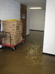
A few days later my first return to the building was to help take photos of damage. We entered through a side door to the mezzanine off the loading dock ramp. Our view as we entered can be seen in the photo below. Everything inside was covered in mud, plaster and paint falling off the walls, and an unrecognizable darkness. Water still had not receded out of the basement so the mezz was as far down as we could go. Up on the first floor, which had taken on about two feet of water, the old wood auditorium floor was completely ruined as were many artifacts in the Spanish American War Memorial room that served as the VMC office.

Over the next few days as water went down to a foot or two in the basement, we recovered the gas pump we had been using the previous and set it up to pump out the remaining standing water. We now had a couple state troopers for 24/7 security, as we took turns “watching the building” – essentially just refueling the pump whenever it ran out. I spent many long days just sitting by the First Avenue doors watching the cars go by.

Not surprisingly, it took at least a week or two for professional cleanup crews to start picking up Vets Memorial, while many other buildings were already underway. Although I was not in position to actually do any cleanup work, they did need someone from our department there at all times as a go-to person and to unlock and lock the building at the beginning and end of the day. Like watching the pump, many afternoons, evenings, and Saturdays were spent simply sitting around at the building. I got to know our regular Per-Mar security gang, which replaced the state troopers as security. Other than that, the night crew and I spent much of the rest of the summer out at Veterans Memorial Park, by the stadium, which is also owned by the Vets Commission.

After returning to Ames this past year for school, I tried to keep up with recovery news from the Gazette and other sites, but it was hard not to disconnect from the flood. With the few days I was back in town for Thanksgiving and Christmas it was hard to gauge the progress. At spring break time in March, downtown had been pretty well cleaned up and many major businesses had returned. But work continues for smaller businesses and other less visible areas, like New Bohemia, Czech Village and Time Check.

Bustling Cedar Rapids

I am back in Cedar Rapids for the summer, following a stimulating semester abroad in Rome and my own travels beyond. (Blog posts regarding those travels still to come…) I am interning at a prominent local architecture firm in downtown Cedar Rapids. Today was my first day; I believe it went well, but I must say I was quite disappointed in the total lack of activity around downtown. Whenever I am away for a long period of time I seem to re-envision downtown as a much more bustling place. Obviously the city center took a major hit from the 2008 flood, and a recent article in the Gazette explains ground level tenant space has been slower to reoccupy; but even so, it’s a bit discouraging when at 10am there are maybe five pedestrians out, just scattered traffic, and several premium on-street parking spaces vacant. (And people still think we have a parking problem) Downtown has a lot of good things going for it right now, and coming on over the next couple of years, so hopefully the situation will improve dramatically. Time will tell.

Once I get my travel posts written, I look forward to shifting focus back to CR. My first topic to tackle will be the controversial proposal to close 2nd Ave for PCI’s new medical mall (a letter to the elected’s could be called for). Also I plan to follow the renovation work to take place at the Veterans Memorial Building, now that City Hall will return there for certain, as well as new developments coming on board like the new convention center and the massive US Courthouse now under construction. Another matter that has recently caught my attention is the on-going demolition of flooded homes in Time Check. It’s time for another great summer in Cedar Rapids.

Letter: TrueNorth Site Best for New Library

Below is a letter that my friend Spencer Barnes and I wrote to Cedar Raids Mayor Ron Corbett, City Council members and the Cedar Rapids Public Library Board of Trustees. The Library Board will make a final site recommendation tomorrow at their 4 pm meeting and the City Council is expected to vote on Feb. 24.

To the City Council of Cedar Rapids:

The new library is arguably the most important city facility to be rebuilt from the flood. It is not only a place to store books and information, but it is a place of community engagement, interaction and participation. The new library will have a profound effect on its surrounding area, therefore site selection should not be taken lightly. We feel the issue of parking has been unreasonably prioritized above other equally, if not more important criteria. Furthermore, we have concern with the way parking availability has been defined at certain sites, in particular at TrueNorth.

The alleged problem with providing parking at TrueNorth is hard to accept, with two large city parking garages so close by. Further, the library board’s demand for 315 free parking spaces is also unreasonably excessive. Even Library Director Bob Pasicznuk said that 200 is plenty for our peer libraries, and Des Moines’ new downtown library, for example, only includes 30 spaces.

By asserting such an extreme and unnecessary parking requirement, this ultimately becomes the main determining factor for site selection. If the city is serious about actually being “vibrant” and “urban”, we must strive for the types of places that are accessible and stimulating – that bring together people from all walks of life for all kinds of activities. Alternative means of getting around need to be recognized and encouraged – biking, walking, and transit. Incentivizing private cars is counterproductive to this goal and is unfair to those who cannot drive. Additionally, as the old library was once labeled as downtown’s biggest attraction, maximization of synergistic benefits needs to be prioritized. The library should be placed in a location by which visitors can easily utilize other downtown services including local businesses struggling to gain a foothold after the devastating flood.

Therefore, we believe that TrueNorth is the perfect location to foster community engagement and continued rejuvenation of downtown. A new library at the TrueNorth site could reactivate the fading Green Square Park, creating a truly cultural community green space – bordered by the art museum, former Carnegie Library, and the First Presbyterian Church. With proximity to the established downtown core, yet on the edge of more sparsely built up blocks, the new library here would promote further urban development in this area. The site is also responsibly far from the river, taking on very little water during the flood, so slightly elevating a new library here could mitigate any risk.

We ask that you take a more balanced approach in choosing a final library site and consider which site has the greatest potential to foster a real vibrant and urban hometown. We believe that site is TrueNorth.

Thank you,

Brady Dorman
Senior in Architecture
Iowa State University

Spencer Barnes
Senior in Finance
George Washington University

Save Sinclair Smokestack

Following the flood in 2008, and two fires this past year at the old Farmstead / Sinclair meatpacking plant, Cedar Rapids is moving forward with demolition plans. After the most recent fire in December, it was announced that the smokestack would have to be demolished due to structural instability. But last week the City Council decided to hold off for the moment in response to a plea from the Historic Preservation Commission to study stabilizing and restoring it first.

Details aside (not really the point of this point), I got to thinking after browsing through the Gazette online reader comments. Some people feel it is an important part of Cedar Rapids history and needs to be preserved while others simply see it as a waste of time and money.

I’ve been in Rome for nearly a month now, living and going to school in buildings that are 400-500 years old, surrounded by other buildings and structures well over a thousand years old. Over the centuries, most buildings in Rome – many that were once very significant – have not survived. They’ve either been abandoned and looted for building materials, or modified for different uses. Only more recently (last century) has there been such a strong preservation push for buildings and sites of antiquity. So being here really puts into perspective what old actually is, not to mention historical.

Personally I would like to see the smokestack saved – I agree it is an important part of our city history, as well as a neat landmark. The difference in “scale” and “significance” from Cedar Rapids’ history and that of Rome is interesting to consider once experiencing both.

Photo credit: Jim Slosiarek / The Gazette

ISU Bridge Studio ideas for Oakhill Jackson / New Bo

Neighborhood Network News has posted video of last Saturday’s (Jan 23) “Imagine a Vital Neighborhood” urban design conference in Cedar Rapids. Architecture students from Iowa State University’s Bridge Arch 601 Graduate Studio presented design proposals and strategies for sustainable redevelopment in Oakhill Jackson and New Bohemia. I haven’t watched the videos entirely yet, but there were a range of ideas from more abstract and statistical to more specific design proposals. One intriguing idea was very ambitious, proposing a residential high rise and retail complex including a Target store – on par with mixed-use urban big box developments found in several larger US cities. A common theme was to reuse building materials (like from Farmstead) for new construction in the neighborhood.

The videos are definitely worth a watch. Special thanks to Robin Kash for posting these and other community meeting videos on Neighborhood Network News.

Neighborhood Network News: Urban Design Conference Videos
> 1 – Intro, Overview and Opening Discussion
> 2 – Student Presentations
> 3 – Discussion of Student Presentations

Imagine a Vital Neighborhood Cedar Rapids

Cedar Rapids-based, non-profit organization S.E.E.D. (Sustainable Ecological Economic Development) will be hosting a Sustainability Symposium “Imagine a Vital Neighborhood” this Saturday with architecture grad students from Iowa State University. Students will present design proposals to stimulate ideas for building a pedestrian friendly, sustainable neighborhood in the Oakhill Jackson and New Bo areas near downtown Cedar Rapids.

S.E.E.D. founder and Oakhill Jackson Neighborhood Association President Michael Richards has been collaborating with the College of Design’s “Bridge Studio” for two years. The first year students developed prototype designs for post-flood affordable housing that received the grand prize for the 2009 NCARB Prize for Creative Integration of Practice and Education in the Academy. Professors Clare Cardinal-Pett, Peter Goche, and Nadia Anderson, who was my studio instructor this past fall, will be leading the event.

Anyone interested in the revitalization of these neighborhoods and making a more livable, sustainable Cedar Rapids is encouraged to attend. The forum will be held from 10am – 5pm, this Saturday, Jan. 23, at the Community Conference Hall in the Horizons Building, 819 5th St. SE. More information about the event can be found on BJ Smith’s Puncture Proof blog.

> Bridge Studio
> S.E.E.D.
> Puncture Proof: Forum promotes pedstrian-friendly neighborhoods

Final Recommendations for CR Transit Improvements

The third CR Transit Study open house was held this week on Tuesday, Nov. 24.  I attended the earlier session from 1-3pm at the African American Museum.  Both consultants Joseph Kern and Bob Bourne were there, as well as Sushil Nepal from Community Development / Corridor MPO.  It was good to finally meet Bob, who was the director of CyRide for 25 years and made it what it is today.  About 20 members of the public were in attendance, including a handful of concerned teachers and students from Prairie.  Mayor Kay Halloran also made an appearance.
I was pleased to see recommendations for system improvements as well as route changes.  Many of these recommendations echo changes I have suggested in previous posts to make the system more legible and user-friendly.  Regarding marketing, operations, and fleet, a few recommendations include: a new system map, real-time bus tracking, getting on Twitter, and displaying a route number, route name, and destination on all buses.

Read my entire review of route changes over at the Cedar Rapids Bus Party blog.

Spring Groundbreaking for Regional Commerce Center


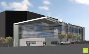
The Cedar Rapids Chamber of Commerce intends to break ground this spring on a new three-story Regional Economic Commerce Center in downtown Cedar Rapids, with completion expected in early 2011. The modern, glass building will replacing the current bland, one-story Chamber of Commerce office at the corner of First Ave and 5th Street NE.

The new economic center was first proposed back in March as a 60,000 square foot, six-story building to house the chamber, convention and visitors bureau, and a number of other commerce-related organizations under one roof. Instead it will be built as a 30,000 square-foot, three-story building. The overall design appears to stay the same, simply reduced to three stories.

Despite the downsize, this is still a positive change for downtown. With the proposed convention center development and upgrades to the US Cellular Center, along with renovations currently underway at Theatre Cedar Rapids, this area along First Avenue through downtown should be seeing some major improvements over the next few years.

> Gazette: Regional Commerce Center close to ‘go’

Older posts Newer posts

© 2022 URBAN THINKING

Theme by Anders NorenUp ↑