Our house will be getting a little fuller this November as Emily and I are expecting our first child! Baby on the way has helped focus a long list of home improvement projects this summer – the baby room now being a top priority. Special thanks to my brother Daniel for creating the video.
Welcome back to Urban Thinking. Returning from a long hiatus, new content will focus largely on home improvement projects, with the occasional urban design and development news post. A lot of exciting changes since my last posting: Emily and I got married in September of 2013, we got a cat, and last June (2014), we purchased our first home – a century-old house in Iowa City. I have thoroughly enjoyed home ownership so far and love investigating every nook and cranny. I’ve been especially interested in the history of the house and identifying what elements are original and what has been modified or added over the years.
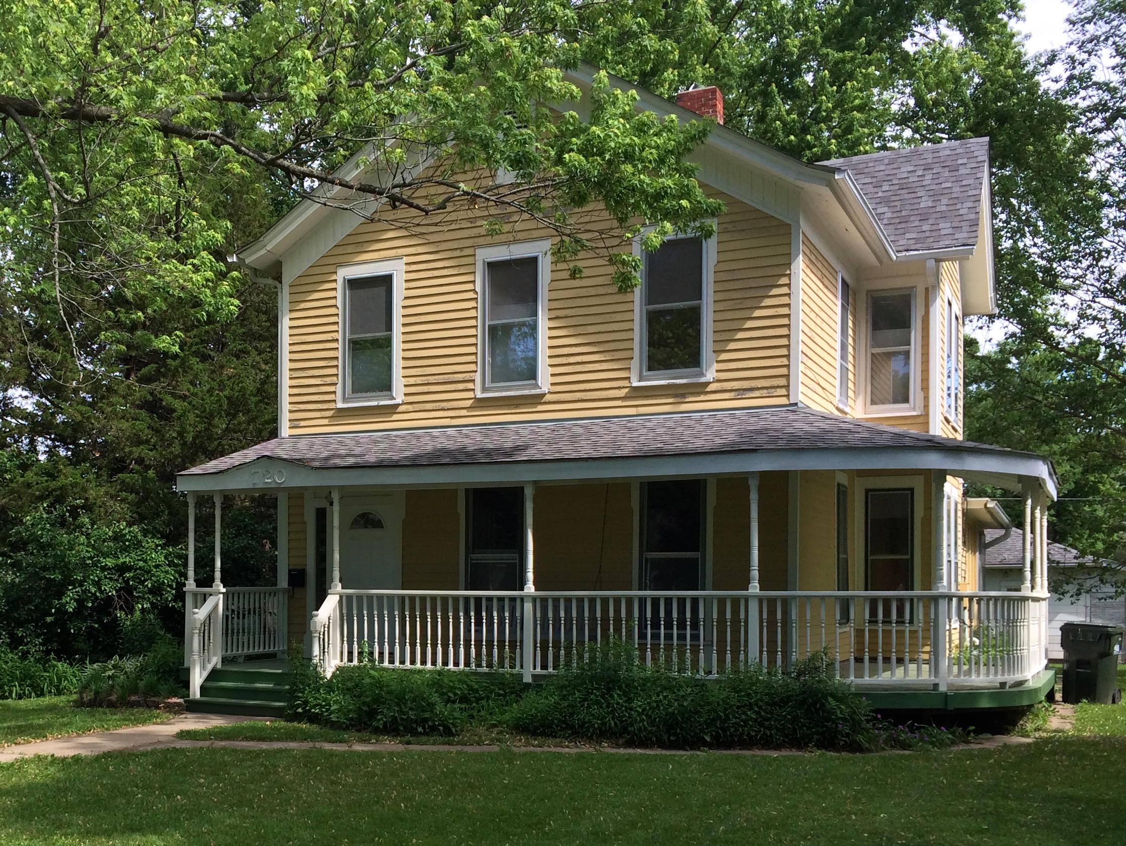
We spent about six months house hunting in Iowa City, starting in late 2013. Our goal was to find an older home with character in an established, walkable neighborhood close to downtown. We quickly realized this particular housing stock is very limited in Iowa City, as the vast majority of houses surrounding downtown have been converted to rental properties with proximity to the university. The occasional house that did come on the market tended to be well over our price range or did not satisfy enough of our requirements. Finally, though, in mid April, we spotted a new listing: a quaint two-story yellow house with a wrap-around porch on Walnut Street, about a mile southeast of downtown. We saw it immediately and decided to put in an offer. The sellers accepted our first offer and we took possession at the beginning of June.
While not quite a “fixer-upper” the house certainly had – and still has – many projects. Overall in good condition, deferred maintenance and upkeep in recent years was evident, as well as some unusual modifications over the decades when the house functioned as a rental property. That said, the owners before us actually did quite a few improvements to bring the house back to a more original condition, such as restoring original wood siding that had been covered in aluminum siding and removing carpet and ceramic tile from original hardwood floors. A significant new addition they made – a master bedroom suite built over a single-story kitchen on the back of the house – was done sensitively to match the scale and character of the original structure. A large deck with a small pergola was added to the backyard as well. These two features were by far the top selling points of the house.
After moving in we focused on deep cleaning, getting the yard in better shape, and taking care of minor maintenance issues that had long been ignored. We repainted a few rooms (entry hallway, living room, and dining room) and gradually purchased much-needed furniture like a couch, dinning table, and dressers for our bedroom.
I have an ever-growing list of long term projects (renovating the kitchen being the most extensive), but am still focused on maintenance issues and improving the performance of the house’s assembly and systems Admittedly I am more excited about the technical improvements than the aesthetic at times, but am trying to be methodical in the phasing of projects. Investing in the building envelope and HVAC system first will ensure a solid and protective foundation for the more fun, visible projects in the future.
My subsequent house-related posts will go into further detail on some improvements I have already performed, and what I am working on now as we head into summer. I have found several home improvement blogs very interesting and informative and hope my new posts will be interesting, if not helpful to others as well.

Construction work is underway on the west bank of the Cedar Rapids for a new amphitheater that will offer an intimate view of Mays Island and the downtown landscape beyond. The amphitheater is being incorporated into a new levee segment between 3rd Avenue SW and the police station – part of a comprehensive flood protection system for the westside should it ever get built. Set to open next summer it is anticipated to attract over 50,000 event-goers annually – good news for the westside of downtown that has long suffered from a lack of vibrancy. Now dubbed “Kingston Village,” the area seems poised for revitalization after being devastated by the flood, which left entirely blocks vacant right in the city core.
The upcoming redevelopment of the Louis Sullivan People’s Bank into a restaurant, office, and housing is a positive sign for the area. Additionally, the former school district building a couple blocks away will be redeveloped into apartments. And perhaps most importantly, the City recently got approval to allow select commercial redevelopment in the 100 year flood plane of flooded properties that were bought out with Community Development Block Grant funds that normally restricts construction of new permanent structures. This constraint now aside, redevelopment can progress despite the political and financial delays to comprehensive flood protection.
Until recently, downtown churches have perhaps been some of the most resilient tenants of the city center. Those that remain have preserved important pieces of Cedar Rapids’ cultural, architectural, and spiritual history. Lately however, more than one historic church in the city core has faced a loosing battle for survival. The changing demographics of the city, like many, with generally fewer residential properties downtown, have caused some downtown churches to lose members, while others have had the opposite issue, with growing membership and the need for larger or additional space.
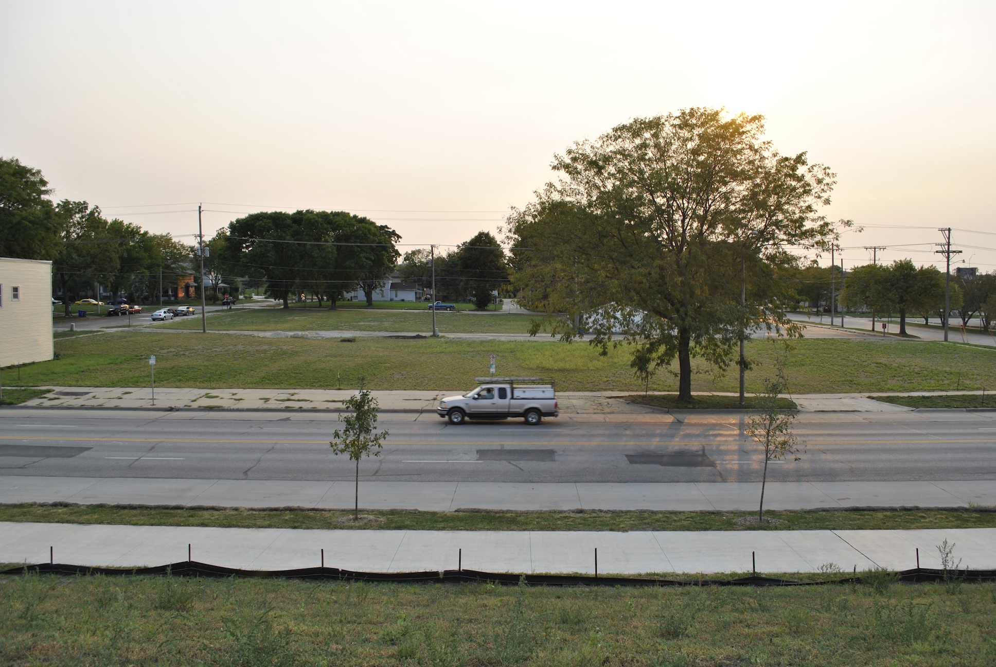
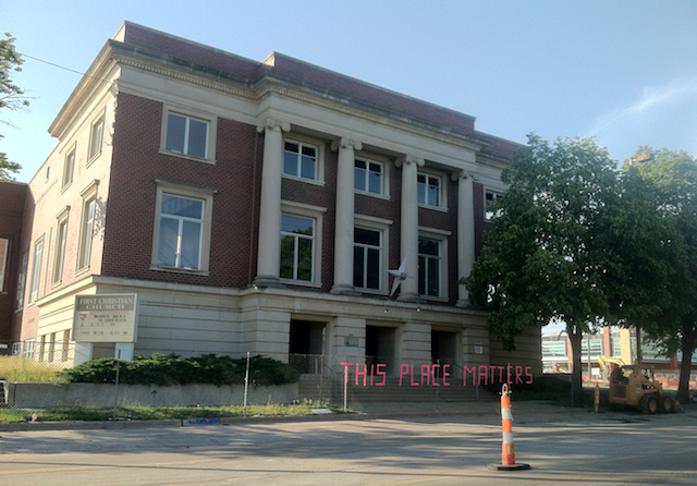
This past October the Peoples Church at 3rd Avenue and 6th Street SE, was torn down to make way for a new office building. At 136 years-old it was the oldest standing church in the city. Now it is the century old First Christian Church two blocks away that appears to be just days from demolition. Tuesday was the 100th anniversary of the building’s groundbreaking on May 22, 1912.
From an architectural standpoint, First Christian is much more significant, with direct design influence from Louis Sullivan and remarkable stained glass windows designed by Louis Mellet. The unique building has a strong civic presence and greatly enhances the urban quality of this block. Built right up against the sidewalk, the church maximizes its site with a flat, rectangular building that appears more civic than religious. Despite missing teeth, the church contributes to a strong urban edge that makes this block of 3rd Ave feel more walkable, dynamic and safe.
The church, now owned by St. Luke’s Hospital is slated to be torn down to make way for about 40 parking spaces to serve the new PCI Medically Pavilion, commonly referred to as the “Medical Mall,” under construction about a block away. St. Luke’s purchased First Christian Church in December 2010 for $695,000, when declining membership and maintenance costs compelled the congregation to sell the building and relocate. At that time St. Luke’s intent for the property was not clear and it was not part of the proposed medical mall plans. (1)
Much contention already exists about the medical mall since the City Council’s controversial decision to close a segment of 2nd Avenue between 10th and 12th streets SE to allow PCI to build on. PCI argued they could not feasibly build up, rather than out, and threatened to build elsewhere away from downtown, citing Hiawatha as a potential alternative. Additionally the City agreed to provide generous financial assistance for the project – $13.24 million in tax increment financing for a parking ramp and associated street improvements. (4)
Supposed to be the catalyst project for the new Medical District SSMIM (self supporting municipal improvement district), the Medical Mall was initially promoted as a more urban building that would infill peacefully with existing important structures. Instead the emerging building is awkwardly situated, very close to two remaining neighboring buildings (Surgery Center and First Lutheran Church) – now part of the large super block created by closing and building over 2nd Avenue. While density generally should be celebrated, it is diminished by the vastness of open parking lots that will now surround the new facility.
Development now taking place in the Medical District has deviated greatly from the type and quality of development and improvements originally presented to the public. In official concept plans developed by Sasaki Associates, the street was not closed, new development densified the district, and character-rich buildings like First Christian remained. According to St. Luke’s, the development site plan was approved by the city “and made public” on February 3, 2011. There was no real announcement, however; nor was it readily available anywhere, so most people were unaware. Once 2nd Avenue was closed, the church still appeared in vague site diagrams available to the public. Even now, on PCI’s own website, the only site plan displayed is an outdated map graphic produced by the Gazette that shows no changes at all to the First Christian block.
In an April 2011 statement released by St. Luke’s, PCI, and Mercy Medical Center regarding the fate of historical structures in the Medical District, St. Luke’s pointed to the city’s code-based parking standards for reason why the First Christian Church site was needed to “support” the required new parking. (2) The hospital offered to contribute the equivalent demolition costs to anyone interested in moving the church. Mission of Hope, a local non-profit agency was looking into this endeavor, but of course it ended up being cost prohibitive. (3)
According to city code, seven parking spaces are required for every 1000 square-feet for medical buildings, but PCI received a variance from the city reducing this requirement to five – which is what the Development Department is now recommending the code be changed to. (6) On Tuesday, February 28, 2011, the City Council agreed to reduce parking requirements for medical buildings from even further from five to 4.5 spaces per 1000 square feet, in hopes to save the church. Despite this, PCI CEO Mike Sundall refused to consider changes, claiming losing the 40 spaces would make parking “really, really tight,” and they were not willing to bear legal fees that supposedly would be involved with this adjusting the plans. (4)
Despite the lowered parking requirements, however, St. Luke’s and PCI continue to perpetuate code-based parking requirements as the key factor in tearing down the church on their reactionary FYI website regarding the church demolition. Parking, clearly is not the real issue. They are obviously land banking for the future, but in doing so are degrading the future vitality of the Medical District as a pedestrian friendly area with mix of businesses, housing, and medical facilities, which they claim to subscribe to.
St. Luke’s plan to tear down the church came to light in early January 2012, when the Historic Preservation Committee (HPC) highlighted it on their “Most Endangered Buildings” list. Around the same time, St. Luke’s applied for a demolition permit from the city. Under recommendation from the HPC, a 60-day hold was placed on the permit. According to city leaders, this is the extent of their legal power to prevent the demolition since it is privately owned and not listed on the National Register of Historic Places.
A newly formed citizen group called “Save CR Heritage” has been rallying since that time trying to work with St. Luke’s and PCI to find an agreeable solution to preserving the building. Supporters held “funeral march” demonstrations in front of the church each weekday during morning and afternoon rush times to protest the pending demolition. In March 2012, St. Luke’s announced they were willing to sell for $900,000 if funds and a proposal could be put forward in a matter of a few short weeks and a down payment of $90,000 in an even shorter period of time by March 23. (5)
According the Beth Chacey DeBoom, Chair of Save C.R. Heritage, the price tag included: $430,000 for the church and ground beneath it (not including the church’s parking lot), $375,000 for two large apartment houses next door, which they insisted must be purchased along with the church; $30,000 for work already done (mostly asbestos removal); and $70,000 in legal fees. St. Luke’s CEO Ted Townsend later estimated legal fees to be as high as $250,000, bring the total closer to $1 million and higher.
Supporters frantically tried to raise funds while looking for potential developers that could support the project. Some local developers were mostly interested in converting the church into condos, but the striking stained glass windows could have been challenging to preserve in place. The most legitimate interest came from Grimes-based Koester Construction that has a lot of experience in historic preservation and adaptive reuse projects.
On April 23, Save C.R. Heritage and John Koester of Koester Construction submitted a letter of interest to St. Luke’s President/CEO Ted Townsend requesting the opportunity to explore several options thought viable for the building’s future reuse, including office space, a boutique hotel, and/or using the space for special events that could be rented for public or private events. The letter requested the structure be maintained in current condition and to retain the stained glass windows intact. This of course did not happen as the stained glass windows have since been removed and some windows now sit open, leaving the inside of the building vulnerable to the elements. So despite several developers expressing interest in the church, the time frame and poor cooperation on St. Luke’s part made it very difficult to raise funds and prepare a business plan according to their demands.
On May 4, even the mayor got directly involved, asking the hospital to consider just donating the church and pledged $300,000 in city funds to go toward redevelopment costs. (6) Considering the immense financial and political support they have already received from the city, it would be appropriate for them to further consider alternatives that have been proposed. But ultimately, St. Luke’s is unwilling to cooperate and is putting their interests ahead of the greater good. As of today it curiously still stands, though it has been fenced up for a week now. Suspicion raises as the holiday weekend nears, if it will begin coming down when nobody is around to see.
It’s amazing St. Luke’s and PCI are willing to put their public image on the line for something so contentious. Overwhelming public opinion is against them and the destruction of First Christian will not be forgiven quickly. This battle appears to be lost, but it most certainly is not the last. First Christian serves as yet another wake up call to Cedar Rapids that we need to think proactively and get ahead of the [wrecking] ball to save the significant buildings we have still have. Which one will be next?
Sources Cited:
1. The Gazette “Sale of historic church to St. Luke’s Hospital raises concern” Cindy Hadish – Jan. 25, 2011
2. Statement from Mercy, St. Luke’s, PCI “Medical District Statement” – April 2, 2011
3. The Gazette “Cedar Rapids panel compiling list of endangered properties” Cindy Hadish – Jan. 8, 2012
4. The Gazette “Last-minute efforts to save historic Cedar Rapids church may be futile” Cindy Hadish – Feb. 28, 2012
5. The Gazette “St. Luke’s Hospital officials say church demolition on hold” Cindy Hadish – April 6, 2012
6. The Gazette “First Christian’s final Sunday” Todd Dorman – May 20, 2012
Apologies for the lack of fresh postings lately here on Urban Thinking. Though I’ve done a poor job of following recent development and urban progress, much has taken place in the past few months and 2012 is already off to an exciting start for Cedar Rapids and the Corridor. The bulk of major flood-induced projects in the city’s core are now well underway, if not already complete. During the past year, much of the major visible progress occurred on the south end of downtown: exterior of new federal courthouse largely complete, conversion of old library to TrueNorth offices, reopening of CSPS, move and expansion of National Czech and Slovak Museum, and streetscaping and continued small-scale redevelopment in New Bohemia.
In this upcoming year much more visible change will be happening on the north end of downtown and more focused in the built-up core. Renovations to the Paramount Theatre are well underway, set to reopen this fall, which will bring another major attraction back to downtown. Similarly the new convention center has begun to take shape just in the past week with steel structure going up quickly along First Avenue. Next door old curtain wall windows are being removed from the hotel in preparation for major renovation, in addition to work inside the US Cellular Center.
Foundations have been poured and daily progress is visible at the site of the new Cedar Rapids Public Library, sitting across from Greene Square Park to the south. A new multistory office building at the former site of the (regrettably) demolished People’s Church is contributing to the expansion of downtown toward the east. Much opportunity exists for infill development and urbanizing underutilized and vacant sites that characterize a fringe between the urban core and surrounding neighborhoods. Along with development in the Medical District along 10th Street SE, namely PCI’s Medical Pavilion and Mercy’s new cancer center, this area has a lot of potential.
Not to say this progress is all flawless or without irreversible consequences. PCI’s Medical Pavilion in particular has stirred much controversy around the closure of 2nd Avenue and excessive surface parking planned on surrounding blocks – threatening yet another beautiful church building, First Christian Church. As noted above, the People’s Church was sadly torn down this past fall after holding the corner of 3rd Ave. and 6th. Street for 136 years. Additionally, throughout the city’s core, continued flood redevelopment and especially the particulars of a flood protection system will put other historical and architecturally significant structures at risk.
Exciting changes and development are a constant for our neighbors to the south in Iowa City as well. Unquestionably a much better urban scene than CR – despite its smaller size – more minor changes and openings in downtown Iowa City and surrounding districts are certainly interesting to follow. While Iowa City tends more than often to “get it right” on creating quality, mixed-use redevelopment, they too have their slips – most notably the recent demolition of a cherished local organic restaurant The Red Avocado. Unlike Cedar Rapids, where most of our demolished treasures are replaced by parking, this quaint house and a few of its neighbors will be replaced by a high-quality, urban mixed-used housing building. Still, it’s unfortunate when even a good development has to destroy something – business or building – that already contributes to the community/neighborhood’s unique character.
The last few months have also brought a number of [positive] changes for me personally, which have influenced my desire to stay around the Corridor for some time. At the end of October I was offered a full time position with an architecture firm here in Cedar Rapids, after spending a few days trying to land a job in Boston. Literally within the same week, I ended up meeting my now-girlfriend Emily. Additionally, I purchased my first car ever, ending my often inconvenient carless lifestyle in the CR. (I had no intention of buying a car had I moved to Boston.) While I’m a huge fan of transit and enjoyed utilizing the system here, it simply cannot fit my mobility needs beyond commuting to and from work. Needless to say, I am now going to be here for a while – and I am thoroughly looking forward to it.
It is an incredibly exciting time to be in Cedar Rapids, especially working in the profession of architecture. Additionally, there really is quite a variety of things to do and see in the area, and it only seems to be getting better. Obviously Cedar Rapids is no Boston or Chicago. An urban lifestyle is not that easy to come by here, but that doesn’t mean there is no urban personality or amenities, simply on a much different and smaller scale. So that is my hope and ambition – to seek out and experience those places and things that give CR and the Corridor its urban flavor and work to promote and support continued urbanism here. There is so much potential in Cedar Rapids, it’s hard not to be passionate and want to be apart of it all. I’m in, are you?
Peter Kageyama, author of “For the Love of Cities” spent a few days in Cedar Rapids last week while in the area for his presentation at TEDx Iowa City on Friday. While in town, Peter met with different creatives/innovators/do-ers and lovers of Cedar Rapids in a variety of formats from casual small groups to larger events directed at young professionals, as well as speaking at the Convention & Visitors Bureau annual meeting on Thursday.
The premise behind Peter’s book and workshops are identifying what it is that makes us love and connect with our cities and how to cultivate and encourage those things. It is the little “love notes” as he calls them that attract us to cities – the cool local coffee shop, a popular farmers market, public art, unique street furniture, etc. that punctuate our daily routines, making cities uniquely our own. The point is, the greatness of cities is the sum of those many little love notes, and they need be nurtured and paid attention to, much the way a romantic relationship between two people would be. In contrast, the overall of cities – traffic congestion, road conditions, politics – things people most often identify as reasons to not love a city, are not things that can be “fixed” and result in significant change or more lovin’. At best, as Peter put it, someone may say “Well the traffic doesn’t suck as much anymore.” No love.
I had the good fortune of meeting Peter last week at a small book club meeting, as well as at a Creative Cities/Beer Tasting event held Wednesday evening at White Star Ale House downtown, geared towards young professionals in the community. It was exciting and encouraging not only to meet Peter, but also with so many others that are enthused and active in Cedar Rapids. I can’t wait to get involved with others working to move our community forward, on large and small scales, rather than just complaining about it. Believe it or not, there’s actually quite a lot of love for the CR.
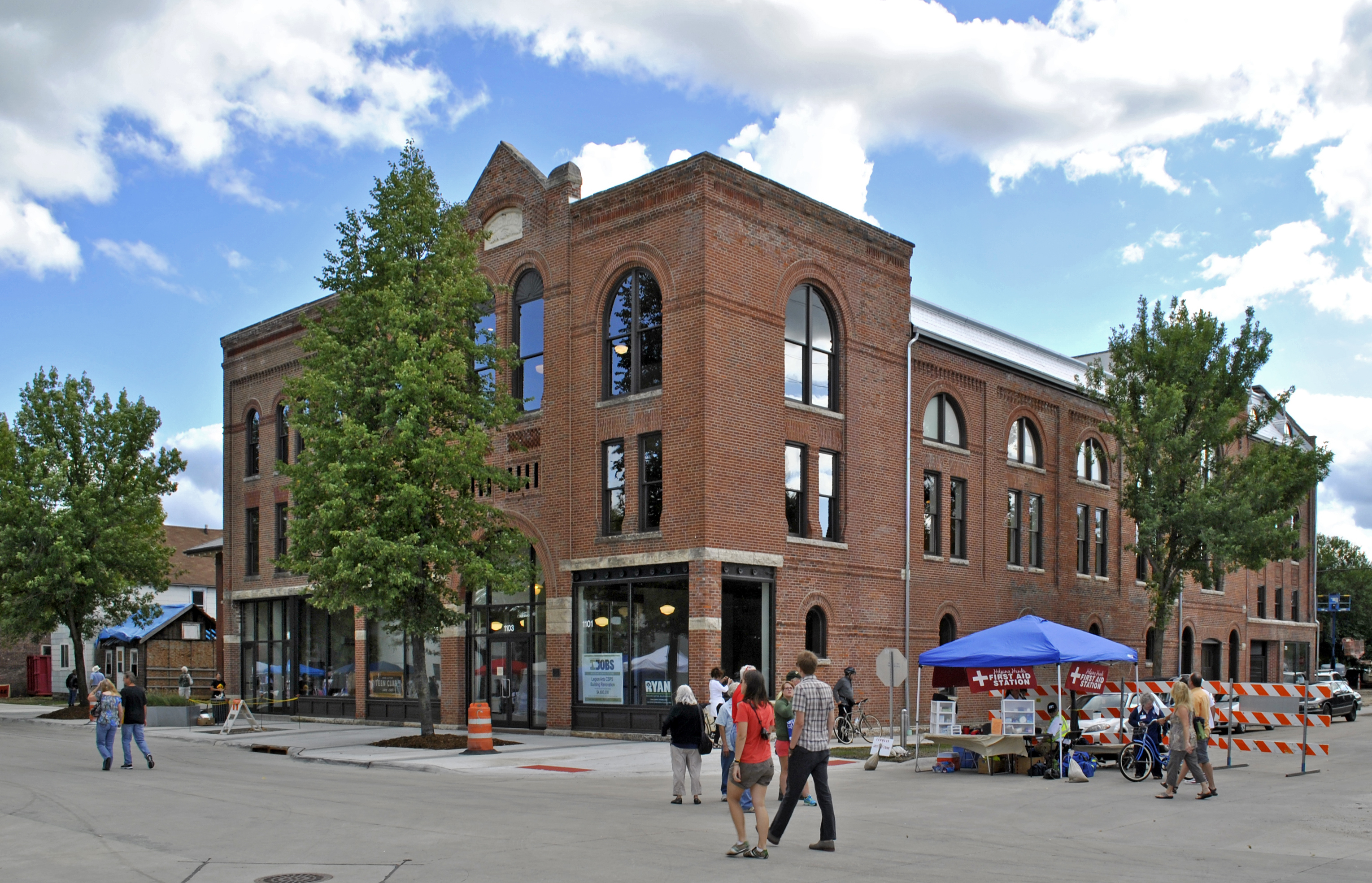
The NewBo Fest was this past weekend, running Friday through Sunday, celebrating all that is going on in New Bohemia, Cedar Rapids’ growing arts district just south of downtown. A newly rebuilt 3rd Street, the active spine through the neighborhood, was bustling with a variety of vendors and multiple music stages, set up at NewBo Park, in front of Parlor City, and underneath the old drive-thru canopy at Capone’s. While a few flood-ravaged houses and empty lots remain, several smaller buildings have been reopened or are currently being restored.
The historic CSPS Hall (photo above), home of Legion Arts, was open to tour, just days after its grand reopening following a multi-million dollar renovation project to improve the facility after the flood. The restoration enhances the building’s versatility for hosting a variety of performing arts, exhibits, and other events. Going back to the building’s historic roots as a Czech social hall, new spaces and improved accessibility will allow a much wider array of events and gatherings, both public and rentable for private functions. Perhaps most exciting is the inclusion of three store-front tenant spaces – two front 3rd Street, flanking the grand arched entry, and one along the side facing 10th Avenue. According to our tour guide, co-director Mel Andringa, there has been a number of interests in the spaces for coffee shops/wine bar, a bookstore, and apparel store. In addition to the CSPS Hall, the old firehouse next door was also renovated to provide space for visiting artists or performers to stay.
A block away from CSPS is the Cherry Building, the nucleus of the creative arts community in New Bo. Built in 1911, as a dairy equipment factory for the J.G. Cherry Company, the building is now divided in a number of studio spaces for artists, creative business ventures, and even an organic lip balm company (EcoLips). Since the flood, the first level was remodeled with new windows and finishes, while the upper levels remain less refined and (presumably) more affordable. Some sculpture pieces were on display in an open flex/exhibit space towards the back, while the hallways provide a canvas for in-house artists to display and advertise their work. The building was open today for the festival and a number of studios and businesses had their doors open – I had no idea the place was so full and active.
Street reconstruction work continues on 3rd Street south of 12th Avenue to 14th Avenue, where a few small businesses have reopened, but the area remains pretty desolate. The corner of 12th and 3rd Street is the main intersection in NewBo, now anchored on three corners by restaurant and bars – Chrome Horse, Parlor City, and recently Capone’s, opening in the former Village Bank Building. The remaining (NE) corner is the final major component, the NewBo City Market. Set to open next spring, the market will transform an existing metal-sided industrial building set back from the street into a large indoor market hall with a large plaza in front for larger open-air markets in the summer and parking in the winter. An historical storefront facade will be salvaged and serve as the front to a new market store building, to be open more regularly than the market itself. Once open, the NewBo City Market will enhance attractions like CSPS, the Cherry Building, and existing bars and restaurants in the neighborhood.
The addition and improvements of these organizations and facilities, in addition to public investment with new streetscaping, have laid a terrific foundation for private investment to follow and really create a lively, active and urban neighborhood in Cedar Rapids. The synergy of these different organizations and facilities in NewBo will be an impetus for attracting more people and infill development, making the neighborhood even more active and resilient. Despite remain pockets of sparseness, the activity at the NewBo Fest this weekend provided a look into what a typical weekend may look like in a year or two. It’s been incredible to watch the transformation thus far, but will be even more exciting to see the changes yet to come. Good things are in store for New Bohemia.


This is a small, two-toned pamphlet from about fifty years ago for the Veterans Memorial Coliseum, which for half a century was the primary events venue of Cedar Rapids. The single-fold flier provides a fascinating look back into graphic design, marketing, and publishing techniques of the mid 20th century.
The literature is quaint and unabashed, celebrating a recent renovation of the then 30 or so year-old building. The inside describes the “fine facilities for all events” and advertises the recently built First Street Parkade (now demolished), a mere “100 paces away,” including an illustration. The text would have been form-set type, making inconsistencies of indentation and line break hyphenation curious. The wide format pamphlets were sized to fit a standard business envelope, perfect for mailing to prospective event organizers.
Today the 33 year-old US Cellular Center is undergoing its first major renovation and expansion since opening in 1978, then replacing Vets as the city’s main events venue. Parallels can be drawn between the Coliseum and current arena renovations. Undoubtedly, though, marketing for the new CR Convention Complex will take a much different approach.
Another fall semester commences next week at Iowa State. After spending five years in Ames I graduated this past spring and am now working as an interim intern at my favorite CR design firm. While I enjoyed my time in Ames, I can’t say I’m too upset about not going back next week. The following, unfinished post might begin to explain why. Please excuse its incompleness, possible out-of-dateness, and the composition skills of a younger me.
“Reflecting on Ames: Lonely by Design”
I began writing this description of Ames back in December 2008. Finals were over at Iowa State and half the population of Ames had left. I stayed in town for a few days to work extra shifts at CyRide – only a few passengers riding my bus. In the middle of winter when students leave, Ames turns into a very empty and lonely place. I was living in Frederiksen Court north of campus at the time, which I always found to be disconnected from the rest of campus and similarly the city.
The whole city of Ames is physically fragmented and divided by greenspace surrounding Squaw Creek. The original city of Ames, where downtown is located, developed about half a mile east of the creek; but when Iowa State was founded, the campus was developed just to the westof the creek. While homes and businesses have been developed to the west of campus, and addition development has taken place to the north and south of the original city, a noticeable void in the middle still remains.

Unlike the University of Iowa, which developed its campus right adjacent to downtown Iowa City, ISU was built in empty farmland, a mile away from town (after all it is an ag school). Because of this, Ames does not have the vibrant and unified, central downtown like Iowa City, but instead two, sort-of ok “downtowns” and no established “heart” of the community.
Lincoln Way, the main east-west drag through town, divides Ames into north and south. It owes its name to the original Lincoln Highway route, running right through the center of town (the modern Highway 30 is now a freeway on the south fringe of town), and was a major development and redevelopment force through Ames’ history. Around the university Lincoln Way is actually quite nice and walkable, but everywhere else it leaves much to be desired. To the east of campus, the road passes through vast open land of the Iowa State Center complex to the south, and intramural fields to the north near University Boulevard, before crossing Squaw Creek. Despite giving visitors the impression that Ames is a sparse, wasteland of meaningless greenspace and parking lots, University Blvd. is the designated gateway to Iowa State.
Along Lincoln Way, the southern edge of campus, is Campustown, a small business district and neighborhood that developed organically right to the south of campus in the late 19th through mid-20th century. Established storefronts line two or three blocks of Lincoln Way and about two, north-south blocks of Welch Avenue. Home to numerous bars, some places to eat, and a few miscellaneous stores and businesses, the neighborhood serves ISU well. Surrounding the commercial district are older houses – mostly used for student rental housing; fraternity and sorority houses, walk-up apartment buildings, and even a few apartment highrises. Mostly built in the 1990s, the highrises were not held to very strict design standards so they were built cheap, are unattractive, and while increasing the density of Campustown (good), it degrades the aesthetic and historic integrity of the area. A few years ago the City of Ames passed a moratorium on new highrises to preserve the historic scale and charm of the area, but an ordinance requiring better design would serve the area much better.
My appreciation for the walkability and mixed-uses in Campustown should not be understated, coming from my freshman year at North Dakota State, which lacked any established campus town area for students to gather and identify as their own. Campustown sustains vibrancy around campus into the evenings and late into the night on weekends. It grounds Iowa State as a place with people, with activity, with life. However the commercial area is relatively small and there is little activity when students are away. Locals tend not to frequent this area – not much to offer them besides the bars – so interaction between students and members of the community is generally limited.
A mile down the road is the real downtown Ames. It is certainly nice enough, but railroad tracks divide it from Lincoln Way to the south, creating a physical and mental barrier. With that, when driving or walking down Lincoln Way, it’d be hard to know you’re just a block from the city’s historic center, as auto-oriented businesses and the Lincoln Center shopping center has dominated this stretch of road for decades. Main Street is a well-kept stretch of continuous storefronts with some fine dining and specialty shops. There are a few taller buildings (maybe five or six stories max) in downtown. The tallest, most dominant structure in downtown is of course the Ames power plant, situated across Duff Ave at the eastern terminus of Main Street, literally the end of town.
Away from Main Street, buildings are spaced out as many historic structures have been demolished over the years for parking and ugly bank buildings. The combination of open lots, railroad obstacle, and literally being just blocks from undeveloped land, downtown has a certain vulnerable feeling to it. It is exposed. Except to the north where it flows fairly harmoniously into a historic residential area, downtown seems cut off to the rest of town, especially its most active arterials (ie. Lincoln Way). Downtown is never visibly very active and the fragmentation of former built-up, urban density does little to create a cohesive, continuous, united-feeling city center.
Ames’ main big box commercial strip is South Duff Ave between Highway 30 and Lincoln Way. Right on the edge of town, the backsides of most businesses face cornfields. Big box destinations include: Target, Super Walmart, Best Buy, Kmart; and south of 30 are Lowes and Sam’s Club. The whole stretch is a mismatch of old remaining sheds and non-retail commercial buildings, next to newer, cheaply built chain stores and restaurants. Most of the big boxes are located far away from the street with enormous parking lots in the way. Some fast food outlets and strip buildings are closer to the road but there is no continuity or consistency. The great distances between buildings and lack of any real massing of building by the road make it feel insecure and aesthetically awkward. Decorative, almost pedestrian-scaled street lamps line the street, but do little for walkers when there isn’t even a continuous sidewalk on either side. And don’t even think about direct pedestrian paths from the street to entrances of stores and restaurants in places a sidewalk does exist – that would certainly be too much to ask.
Honestly the most, consistently active place I know is inside North Grand Mall. Located at the north edge of town, mostly surrounded by medium and low density residential, the mall is not physically well-kept, but maintains decent occupancy and mid-level retailers because it’s the only one in town (though a new “lifestyle center” mall is supposedly in the works at I-35 and E 13th Street). To compete with the new mall, North Grand is proposed to undergo a major renovation that will transform the entire south end (former Sears and Walgreens location) in to an outdoor, mini lifestyle-center adjacent to the spruced up existing indoor mall. Despite being announced well over a year or two ago, little has happened with either shopping center development. One glimmer of hope, though – a new, stand-alone Walgreens has been built at North Grand as an outparcel by the main entrance. This opens up the old attached Walgreens space, with the already vacated Sears store to make way for the “Shops at North Grand.” Regardless the new Walgreens is an attractive building and fills part of the long spatial void of the parking lot along Grand Ave.
Also in the area – a Wal-Mart and Cub Foods are located north of the mall. Further north is a small strip mall with a terrible name, “The Northern Lights Center.” The commercial buildings are generally surrounded by inexpensive apartment complexes, duplexes, and then flows back into single family neighborhoods.
[This post was never finished…sorry]

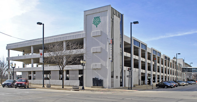

After fifty years of gracing Cedar Rapids’ downtown riverfront, the First Street Parkade and its iconic spiral ramp have reached their end. Built in 1961, the four-story ramp would provide over 400 parking spaces for patrons of the downtown retail scene, as competition from newer suburban outlets was increasing. In recent years the structure’s use would be dominated by daytime office workers.
When constructed the new parkade had a commanding presence downtown – few structures at that time occupied the entire length of a city block. Three elevations (north, east and south) that did not face the river were characterized by long, level horizontal planes, articulated by minimalist vertical supports. Along First Street, sections of the top deck wall were clad in dark tinted glass, perhaps an attempt to break up the non-varying facade to relate to the scale of existing storefront buildings across the street.
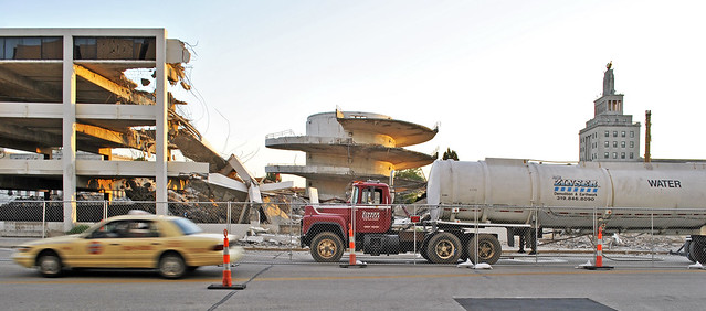
The river facade was much more dynamic. Angled ramps that let motorists ascend to the top deck were left undisguised, sloping in the same direction as river’s flow. The center was marked by an incredible spiral ramp, partially extending out over the water, cutting through the elegant balustrade lining the existing river wall. Exposed by the demolition process, the concrete spiral was self-supporting, cantilevering from the massive circular core.
While the spiral certainly added a point of visual interest along the river, more impressive was the experience driving down it, framing a sequence of views toward iconic public buildings like City Hall, the county courthouse, and the municipal greenspace of Mays Island. The orientation of views from the ramp reinforced long-standing symbols of civic pride. Likewise the parkade was a new point of pride for the city – a sign of modern progress and optimism for the future, heralded as a means to save downtown from its looming demise.
After the 2008 flood, replacing the First Street Parkade became more imminent, having already reached the end of its useful life. Once demolition is complete the site will be turned into surface parking for the time being – an acceptable temporary use. The important riverfront site is now ripe for redevelopment and, once again, has the opportunity to be a catalyst for downtown progress and civic pride for fifty more years to come. Only this time, it will be for people, not cars.
© 2022 URBAN THINKING
Theme by Anders Noren — Up ↑